The Best Hiking Trails In Scotland For Picturesque Views, According To A U.K. Resident
Scotland is the second-largest country in the United Kingdom by land area, yet it is home to only 5.5 million people. The largest portion of the land mass consists of its highlands, a 10,000-square-mile region of hills, mountains, and lakes inhabited by fewer than a quarter of a million people. Scotland is indeed a nation of mostly empty wilderness.
A hiking trip in Scotland, however, requires a minor linguistic adjustment, although English is the official language. Lakes are quite famously referred to as lochs, valleys as glens, and wide valleys with rivers in them as straths. Mountains are called bens or creags. An eas is a waterfall; a dal is a field. Meanwhile, a coire is a deep, hollow on the side of a mountain.
Such terms are an intrinsic part of hiking nomenclature. A walk to Eas Mòr on the Isle of Arran will most certainly take you to a stunning waterfall. Any ben that intersects your journey is most probably a mountain. Those who venture into a place with a glen in its name can expect a steep climb out of it. It all takes a little time to get used to, but it's well worth the effort. As a hiking enthusiast who has lived half of my adult life in Scotland, I present this list of the best hiking trails in the country through a combination of research and personal knowledge.
Meall Fuar, Loch Ness
It is perhaps a shame that Loch Ness is best known for its association with a mythical monster. Certainly, a tongue-in-cheek search for Nessie is one of those activities you should not skip on a trip to Scotland. But take even a half-step back from the tourist-drenched memorabilia, and you'll find that the lake has so much more to offer.
The Loch itself is situated in the Glen Mor, a topographic feature that bisects most of the highlands. At 23 miles long and with a depth of 788 feet, the Loch is the largest body of fresh water in Great Britain. Roughly cigar-shaped, its northern end is only 6.7 miles from Inverness Castle. The hamlet of Fort Augustus sits hard against its Southern Coast and is considered a traditional jumping-off point for further exploration.
Hiking opportunities abound, although a complete circumnavigation of the Loch is not for the faint-hearted. Great forested areas fringe the lake's circumference, interspersed with vast stretches of moorland and quaint villages. Such a journey is something of a week-long affair. For those with less time on their hands, a hike toward the Meall Fuar is more manageable. At 2,293 feet, it is the most prominent summit around the Loch and, as such, offers some of the best views in the area. The village of Bunloit, some 4.4 miles south of Urquhart Castle, makes for an excellent jumping-off point. From there, the ascent is straightforward and can be completed in 3 to 5 hours, stretched over a total distance of approximately 5.6 miles.
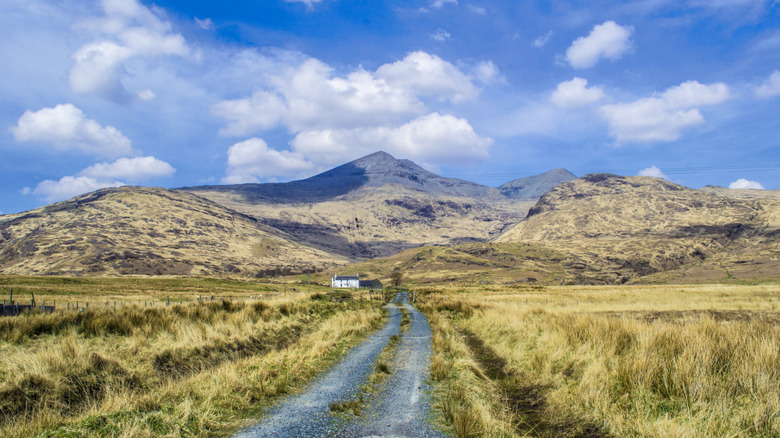
Ben More, Isle of Mull
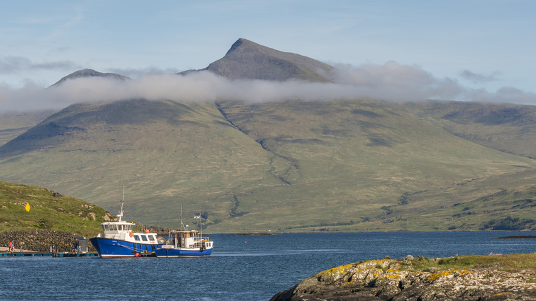
The rugged coastline of the Isle of Mull sits off Scotland's West Coast and forms part of the broader Inner Hebrides. The landscapes here are dramatic, to say the least. There are around 300 miles of coastline to explore, and only one significant settlement, Tobermory. Here, the majority of the island's 1,800-strong population lives. The island is accessible only by ferry, which runs between the nearby resort town of Oban and the island village of Craignure. From there, you can take the 3.4-mile hike toward Duart Castle, the 700-year-old historical seat of the Maclean clan.
Activities on the island range from whale-watching to cycling tours. The exploration of Mesolithic structures, such as the Lochbuie Stone Circle, comes as a bonus. Those seeking a hiking challenge, however, often turn to Ben More. The only island mountain outside of Skye, it stands over 3,000 feet high and offers superb views of the surrounding countryside. Prospective travelers can begin their journey at the aptly titled Ben More car park, passing by the farmstead of Dhiseig and continuing upwards. The distance is only 5.75 miles, but the nature of the terrain means that the round trip takes around 5 to 6 hours in total.
Although less technical than some Scottish Munros, there are some inherent dangers to watch out for. Certain areas can be boggy regardless of the time of year. The weather is also famously unpredictable: Fierce winds blowing in from the North Atlantic are common, making hiking conditions hazardous. Tourists need to think carefully about the clothes they pack for such a vacation in Scotland.
The Great Glen Way
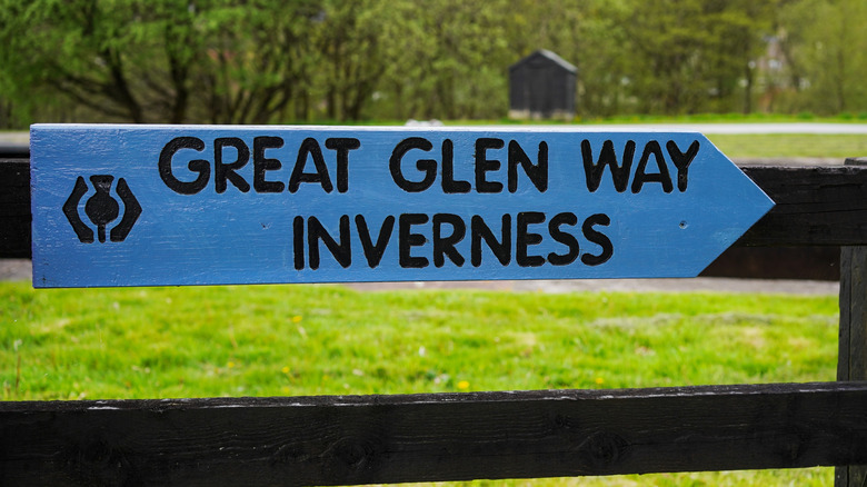
The Great Glen Way is a rugged and topographically beautiful fault line that divides Scotland's coasts neatly in two. The trail begins at Fort William, a small town in the West Highlands known as the gateway to Ben Nevis, which lies just 1.7 miles away. From there, the valley extends to Inverness, 61 miles distant, and passes through some of Scotland's most stunning landscapes.
Those traveling the entire length of the way pass by no fewer than 3 lochs, the first of which, Loch Lochy, is a 14.8-mile hike from the starting area. The low-lying lake provides incredible views of Ben Nevis alongside sweeping vistas of the Caledonian Canal. Meanwhile, Gairlochy lighthouse marks a popular spot for wild swimming. Further north, there are some fantastic places to stay, ranging from castle hotels to rentable cottages and boarding houses.
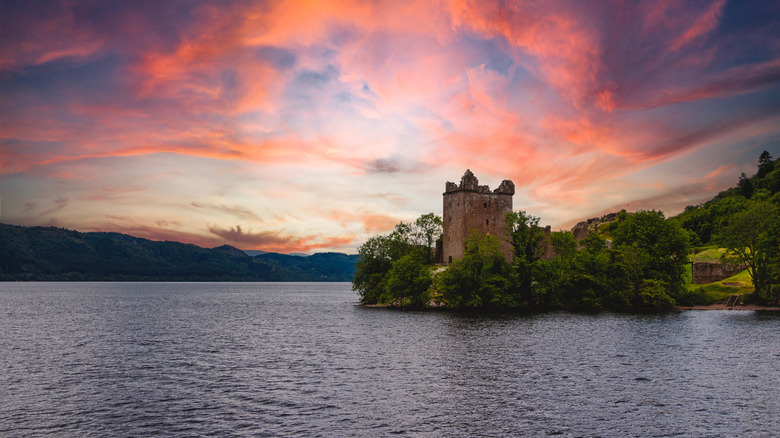
Next up is Loch Oich, linked to its sister lake to the south by the Caledonian Canal. A masterpiece of industrial design, it was built by the much-celebrated 19th-century civil engineer Thomas Telford. The lake is around 4 miles long, and no more than 0.5 miles wide at any point. Like so many Scottish lakes, it is also perilously deep. Kayaking is a popular activity here, and many walkers enjoy circumnavigating the Loch, a challenging, 14.5-mile hike that takes 6.5 hours to complete. Those heading further up Glen soon arrive at the forested banks of Loch Ness and the short jaunt toward Inverness. This lively city is well-positioned as a gateway to the country's far reaches, allowing travelers access to some of the best stops along Scotland's North Coast.
The Kintyre Way
The Scots Gaelic word "mull" translates to island and is derived from the older form of the word "maol," meaning bare or bald. In geographical terms, it refers to any land formation that lacks trees. The Mull of Kintyre is one such place, the windswept Southern edge of the Kintyre peninsula. The peninsula itself lies sandwiched between two islands: Arran to its east and the Isle of Islay to the west. Down at its southern tip, the landmass is characterized by sand beaches and prolific wildlife. An 18th-century lighthouse still guards the way.
Some 16 miles north of the Mull, sits Campbelltown, and the opportunity to sample one of the highlights of any trip to Scotland via a tour of the town's many whiskey distilleries. Meanwhile, the Kintyre Way allows you to take stock of either location. The 100-mile-long hike begins in Tarbet, a small fishing village at the peninsula's northern end. The trail then cuts a path south for 9 miles, before striking west to Clachan, another small village and the site of an ancient church.
From there, it zigzags its way to Campbelltown before settling on a coastal route south. The last leg cuts across the southern tip of the peninsula toward the islands' second main settlement, Southend. Lastly, weary travelers make their way toward the adorable village of Machrihanish on the East Coast. Along the way, such hikers are treated to incredible sea views with the mountain-dotted islands in the foreground forming an Instagram-worthy backdrop.
The John Muir Way
The John Muir Way is a coast-to-coast route named in honor of the famous Scottish-American naturalist. Some 134 miles in length, the trail takes you on a journey from Helensburgh in the west to Dunbar on Scotland's East Coast. Helensburgh itself is an old Victorian holiday resort that has retained much of its former charm. It's just a shade over 22 miles from Glasgow, and the beginning of the John Muir Way itself rests close to the waterfront and is marked by a circular plinth of stone.
The first stretch takes you east toward what is arguably Scotland's most beautiful lake. Loch Lomond, the town of Balloch, and its famous castle have always been a welcome sight to the weary traveler. The lake's proximity to the astute hiker's bad-weather haven of Glasgow brings certain advantages. Indeed, it is an ideal destination for those looking to visit Scotland during its most budget-friendly season.
Regardless of the time of year, the trail winds its way gently east through the rolling hills and picturesque villages of rural Scotland. A welcome pit stop in Edinburgh, one of the U.K.'s most stunning and historic cities, presents opportunities for a solo or group adventure. Meanwhile, the final stop of Dunbar also fails to disappoint. A pleasant, sleepy coastal town, its ruined castle — a former haven of Mary Queen of Scots, no less — looks out over the bay as it has done for over 800 years.
The Quiraing, Isle of Skye
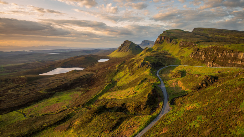
The Isle of Skye is one of those places that frequently appears on lists of must-visit locations for avid hikers. Wild, windswept, and steeped in legend, Skye has long been one of the top tourist draws in Scotland. Getting to the island is a hassle-free task these days, thanks in part to the construction of a toll-free bridge connecting it to the Scottish mainland. Once there, activities abound, many of which are clustered around the island's main settlement of Portree, which lies some 33 miles from the Bridge of Skye.
For hikers wishing to pass through some of the most stunning landscapes in Scotland, a short loop through an area known as the Trotternish ridge does the trick. Here, a massive ancient landslip sculpted the landscape, twisting it into impossible shapes reminiscent of cresting waves on the ocean. The formation known locally as the Quiraing, at 1.2 miles long, is the largest of its kind in Britain. Hiking to it is a 4-mile loop through some of the most impressive topographical features around. The terrain is generally good, although it becomes rocky in some places.
Sites to look out for include: The Prison, an enormous slab of volcanic rock. The Needle, a Tolkienesque narrow pillar of basalt that points to the sky. Lastly, there is the Table, an incongruously flat area once used to shield cattle from the voracious appetites of marauding Vikings. Those looking for a longer, if not necessarily more challenging hike, can continue south toward the Old Man of Storr — a 180-foot-tall spire of weathered basalt — some 15 miles distant. The walk can also be attempted by heading north from Portree and completing a 3-mile circuit around one of Europe's most otherworldly features.
Ben Nevis
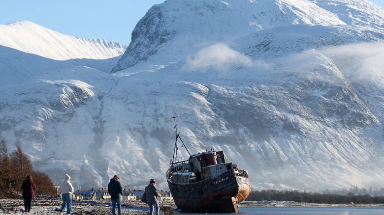
Ben Nevis might be short in stature when compared to other mighty peaks, but in the British Isles, it stands very tall indeed. At 4,413 feet high, it's less than a quarter the size of Mount Everest, but scaling it is still a 6- to 9-hour epic journey that requires skill, stamina, and expertise. The good news is, the route is walkable. Most approaches begin on the east side of the mountain in the small town of Achintee, situated less than 2 miles from Fort William. Here, you will find a visitor center where you can purchase maps and trail equipment.
The round trip is only 10 miles or so, but poor weather conditions — which are common and severe — can seriously hamper attempts. Runners taking part in the annual Ben Nevis Race can usually complete the circuit in around 90 minutes. Still, a more sedate place is generally recommended for all but the most hardcore of hikers. Ben Nevis is far from an easy climb.
Those lucky enough to reach the top are treated to a 360-degree panorama of the surrounding area. Ben Lomond is visible, as is Northern Ireland on a clear day. The Great Glen Way also stretches out to the west and even the Torridon hills, some 104 miles distant (although half that as the crow flies), occasionally peaking above the distant horizon.
The West Highland Way
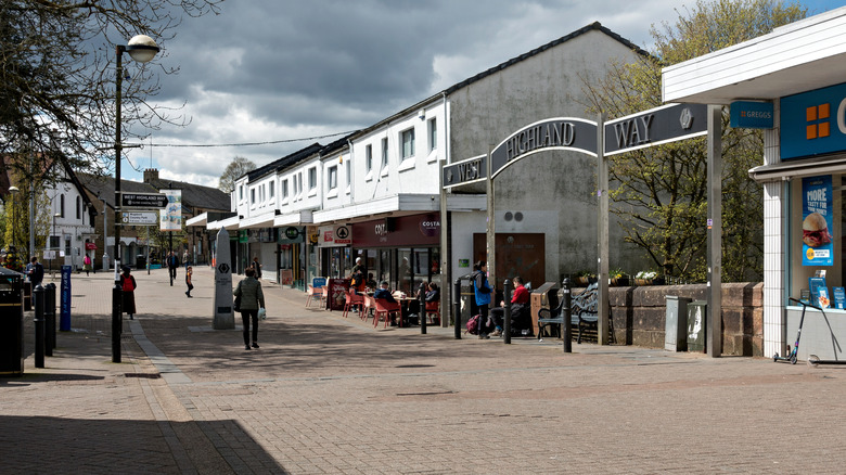
The close approach to Ben Nevis from Achintee remains the most direct, but it is far from the only option available. The West Highland Way begins far to the south in Milngavie, a northern suburb of Glasgow situated some 98 miles from Fort William. The Way is often described as Scotland's best-loved long-distance route. Such an accolade is not granted without reason. Its popularity may stem from its metropolis-to-Ben convenience, but it's also a trail laden with variety. The fact that it's relatively easy going and more accessible than some other nearby trails is a bonus.
Those taking the path pass by the ruins of Buchanan Castle as they wind toward the serene waters of Loch Lomond. Heading north via the lake's east coast, the trail leads to the vast expanse of Rannoch Moor. Peat bogs and pine forests line the way forward. The landscape here is bleak, but devastatingly beautiful nonetheless. The trail then sweeps past Loch Tulia, close to the Bridge of Orchy, and offers some incredible views of the Glencoe Mountains. Such sights broaden as travelers make their way toward Kinlochleven and the lake that gave the town its name.
The final 15-mile stretch winds through forested areas toward Fort William and is filled with glimpses of the ever-majestic Ben Nevis. The decision to push on from the summit is a matter of personal choice; it's not officially part of the Way. Still, the temptation is ever-present for those willing to take appropriate safety precautions.
Fife Coastal Path
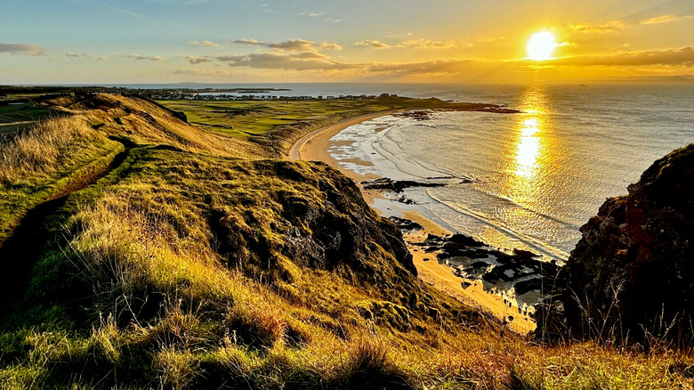
The East Coast of Scotland is generally less rugged than the West. It is a place of fishing villages, farmland, pristine beaches, and mighty castles. Edinburgh does, of course, dominate the region. The capital's unmatched festival calendar is just one reason it is often considered part of the most entertaining cities in Europe. Those planning a visit would do well to include the Fife Coastal Path, or at least sections of it, in their itinerary.
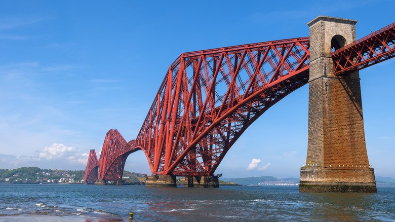
The trail is 113 miles long. It begins in Kincardine, a small town nestled on the banks of the Firth of Forth, a little over 11 miles from Stirling, home of the National William Wallace Monument. The word "firth" is the Old Norse term for fjord, although in Scotland, such estuaries are often broader and less steep. Regardless, the path follows the Firth out to sea, mirroring the latter half of John Muir's, but on the north bank, as it curls toward the northeast. The trail passes close enough to Edinburgh to risk a detour to peruse some of the most charming bookshops you'll ever encounter. Those who resist the temptation will, instead, pass by one of the world's most beautiful crossings, the magnificent and iconic Forth Bridge.
As the route presses on, it makes its way to the coast before snaking toward the city of Saint Andrews. It is a place filled with charming medieval streets, an ancient university, and is the self-proclaimed home of golf. The last leg takes you up toward Newport on Tay and distant views of the Highlands. Curving back in on itself again, down yet another firth, the path leads to the tiny fishing village of Newburgh and the end of a most satisfying journey.
The Lost Valley, Glen Coe
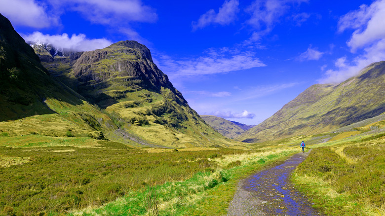
Glen Coe lies South of Fort William. A narrow valley sculpted by ancient glaciers, it is a place of dramatic peaks, stunning views, and a near-palpable aura of mystery. The national park is home to no fewer than 41 trails, any one of which would make a worthy addition to a hiking itinerary. Still, few walks are quite as satisfying or indeed as photogenic as a visit to the lost valley of Coire Gabhail.
The valley is not hidden in the sense that few people know where it is. Indeed, it's found a mere third of a mile from the Three sisters of Glen Coe, the most photographed location in the park. Instead, the name was picked up during the 17th century when the McDonald Clan began to use it to hide stolen cattle. In 1692, as the clan hid in the valley, they were massacred by their own guests. The event was so outrageous that it later inspired George R. R. Martin's Red Wedding from the "Game of Thrones" series.
The trek to the valley starts at the car park just below the Three Sisters' Viewpoint, and winds south through rugged terrain. It's only 2.5 miles to the Coire itself, but the round trip is likely to take three hours or so. There are high river crossings to contend with, slippery rocks, and the ever-present danger of bogs to avoid. Still, those who brave the elements and reach the mouth of the valley are treated to not only a spectacular sight but also to a brush with history itself.
Methodology
I know most of these trails personally, though some of them, such as John Muir Way, Ben Nevis, and the Mull of Kintyre, are famous in their own right. I cross-referenced my own background knowledge with some ready-made lists published on VisitScotland, Tripadvisor, and AllTrails. In terms of parameters, I stuck with accessibility and picturesque value. I did not select trails or Ways that have not appeared at least once on a "best" list.