San Francisco Locals Recommend This Park For Panoramic Views Of The City
We may receive a commission on purchases made from links.
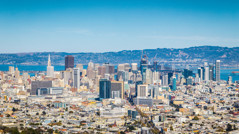
As far as famous cityscapes go, it doesn't get much better than the stunning panoramic views of San Francisco from the lofty heights of Twin Peaks Park. Attracting both visitors and locals alike, San Francisco native Karen summed it up well on their blog, Fog City Secrets: "San Francisco has lots of great viewpoints, but I think Twin Peaks has the best overall view of the city and its beautiful natural setting." Located smack bang in the middle of the city, Twin Peaks is instantly recognizable by Eureka Peak to the north and Noe Peak to the south. It wasn't always known by this name, though. When Spanish settlers arrived in the 18th century, they named the area "Los Pechos de la Chola," meaning "Breasts of the Indian Maiden." As the city came under American rule, it was eventually renamed Twin Peaks.
With an elevation of nearly 1,000 feet, you'll get near 360-degree views that take in the rest of the city and surrounding Bay area. From the top you can see the Golden Gate Bridge, the Transamerica Pyramid, and the Bay stretching out towards Alcatraz. Offering a different perspective depending on the time of day you go, many visitors make their way to the top early in the morning to watch the sunrise or later in the evening to watch the city glow at sunset for one of San Francisco's most romantic activities.
You should, however, avoid going up there as the fog rolls in. As local blogger Vanessa of Venture Beyond the Picture explains, "Beware of the fog though — especially in summer, there may not be many days when you can actually see a lot from there. Even if the sky is clear downtown, that doesn't necessarily mean it's the same closer to the ocean."
How to reach Twin Peaks Park
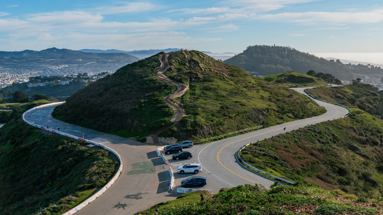
There are several ways to reach Twin Peaks Park, although they all follow the same winding road. To make the most of the surrounding area, walking there takes you through the nearby Castro and Noe Valley neighborhoods with their colorful Victorian houses and small local shops. As you continue climbing, paths and stairways branch off from the road and lead up to the peaks. Wear decent walking shoes to tackle the steep climbs and descents, and be sure to dress warm. It can get pretty windy up there and surprisingly cold. San Francisco has an extensive public transport system, but even if you take the metro to Castro Station or get off at the nearest bus stop on Crestline Drive, there's still a short climb to the top.
This steep climb may not be for everyone, but luckily you can drive to the top, which would make a scenic end to your Seattle to San Francisco road trip. Follow Portola Drive onto Twin Peaks Boulevard, where you'll find free parking at the Christmas Tree Point parking lot. Although it's not very big, places do free up quickly. As a bonus, there's a telescope there to take a closer look at the city below. Just make sure you have 50 cents in your pocket to use it. Karen of Fog City Secrets says, "If you come before 10:30 a.m., there'll be fewer people. But even with more people up there, it's not that crowded. It just might mean waiting for a parking spot if you're driving. I rarely have to wait long for a space. Plus there are other places to park up there."
Tours and hiking around Twin Peaks, San Francisco
For a sightseeing tour through some of San Francisco's best-known landmarks, the Vantigo Original San Francisco VW Bus Tour is a fun way to cruise around the city. With room for up to seven people, the vintage Volkswagen camper van passes by places like the Golden Gate Bridge and Chinatown, giving you the opportunity to find out more about local history and culture. The three-hour tour costs around $129 and includes a short stop at Twin Peaks — just enough time for some fun photo opportunities. For a similar but less intimate experience, the San Francisco Grand City Tour takes you around the city by coach. This tour costs around $69 with an optional bay cruise and bike rental upgrades.
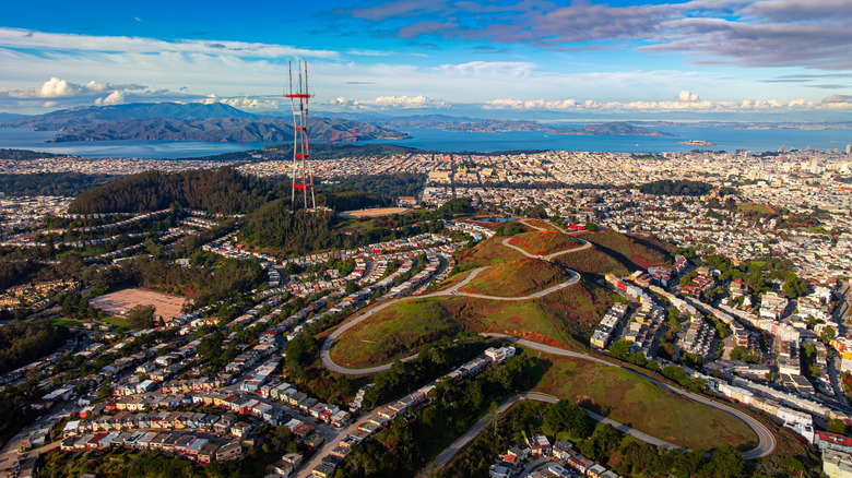
Make the most of the views by hiking your way around both peaks on the Twin Peaks Trail. Starting at the bottom of Twin Peaks Boulevard, the trail follows the road up and skirts around the peaks with optional tracks leading up to the summits. The 275 feet of elevation over 2 miles makes it a fairly challenging but scenic hike. For the more adventurous, the Twin Peaks and Mount Sutro Loop Trail is a 4-mile hike that takes in the forested slopes of Mount Sutro. You'll also get a closer look at the famous red and white outline of the Sutro Tower, San Francisco's television and radio broadcast tower. The trails are pet friendly and popular with local dog walkers. Wildlife is pretty scarce around Twin Peaks, as you'd expect, but it is home to the federally endangered Mission Blue butterfly. The best time to spot them is in April and May when they are often seen on the pretty silver lupine plants they're attracted to.