Driving Along This Scenic Byway In New Mexico Provides Captivating Fall Foliage Views
Few states have a bolder style than New Mexico. This is the land of adobe dwellings, otherworldly rock formations, and the bleached dunes of White Sands National Park. These images extend to souvenirs as well: here you'll find Sasquatch T-shirts, UFO mugs, and Navajo-style blankets. Even the New Mexico flag and license plate are the most distinctive in the U.S., with its image of a red "Zia," or sacred sun. This is a state that takes great pride in its culture and landscapes, and if visitors aren't shopping for turquoise jewelry, they're probably digging into an entrée packed with green chilis; there's a reason a New Mexico vacation is a must for spice lovers.
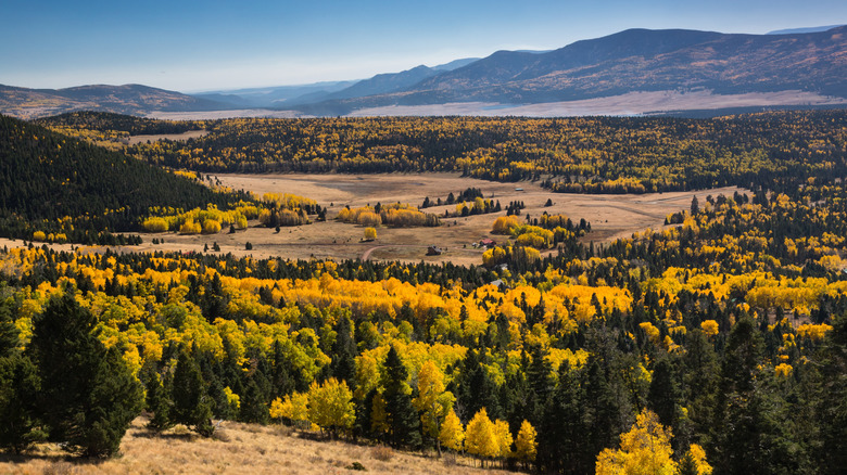
Yet few newcomers think of fall foliage. If you've never been to New Mexico before, you assume this southwestern state is full of deserts and cacti, with only occasional cliff dwellings to break things up. You might not have any idea how dramatic New Mexico's topography is, ranging from 2,800 to 13,000 feet above sea level; the Southern Rocky Mountains extend into the state, and Santa Fe has a higher elevation than any other state capital, at about 7,200 feet. Not only does much of the state experience beautiful autumns, but swathes of New Mexico receive mounds of snow, making it a popular ski capital.
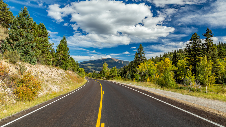
One of the best ways to experience a New Mexico fall is by driving the Enchanted Circle Scenic Byway, an 87-mile loop through the state's high country. The scenery is spectacular year-round, but a sunny day in October should dazzle you with blankets of red and yellow leaves. Not only does the route live up to its name, but it also lives up to the state's nickname, "Land of Enchantment."
The background and beauty of the Enchanted Circle
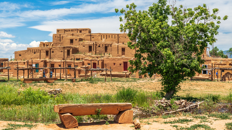
The Enchanted Circle was officially designated a Forest Service Byway in 1989, two years before the National Scenic Byway Program was enacted by Congress; the latter title would come in 1998. Yet this region has long captivated new arrivals: Indigenous nations have lived in these highlights for millennia, and European colonists arrived as early as 1540. Waves of settlers found inspiration in the land and people, marveling at spectacular vistas and mimicking the bronze-colored architectural style that the Pueblo peoples had mastered. For over 1,000 years, people have lived in the place known today as Taos Pueblo, a community famous for its multi-story adobe construction. This southwestern town is a must-visit for fall views and adventures.
Taos is also a major destination for road-trippers on the Enchanted Circle. The classic itinerary starts travelers in Red River, a high-elevation town famous for its outdoor diversions and epic ski slopes. Drive south for the peaceful beauty of Eagle Nest, an isolated village with plenty of summer home rentals. Keep southward to hit Angel Fire, a ski town with hiking, mountain biking, and lake paddling in summer. From there, drive west to Taos, where you'll not only find traditional buildings but also art galleries, hot springs, and the geologic wonders of the Rio Grande River.
Mile-wise, the full Enchanted Circle isn't very long, and you can drive the entire route in under three hours. Do yourself a favor, though, and stop often; these towns excel at welcoming guests, and the autumn views in between are as splendid as they get.
Getting to the Enchanted Circle and where to stay
To start, you could always get to this region by car. New Mexico is a coveted destination for cross-country road-trippers; in fact, hundreds of miles of Route 66 still cut through the state, having ushered generations of travelers through the southwest. The drive from Santa Fe to Taos is considered one of the coolest road trips of the summer, and there's no reason you couldn't start your Enchanted Circle journey there (or drive up in the fall). The well-trafficked motorway is suited to just about any kind of vehicle, from compact cars to RVs to motorcycles, and a handful of EV charging stations are scattered around the loop, most of them in Taos.
The closest major airport is Albuquerque International Sunport, a solid three-hour drive from Taos. Santa Fe has its own regional airport, which is a bit closer — one hour and 40 minutes away by car — but it services far fewer cities, all in the southwestern U.S. Mass transit options are extremely time-consuming, and completing the Enchanted Circle without a car is almost impossible.
That said, you can legally ride the byway by bicycle, and many people have pedaled this circuit, usually in warmer months. This district is a magnet for sporty visitors, and you may be tempted to hike Wheeler Peak, a challenging summit right smack dab in the middle of the Enchanted Circle. Attempting this route will be bitterly cold in autumn, but the views are, well, enchanting.