This Popular Hiking Destination In The Pacific Northwest Is Worth Adding To Your Bucket List
The Pacific Northwest (PNW) is a region unofficially defined as Washington, Oregon, sections of Idaho, and British Columbia in Canada. It's a magnet for hikers seeking untamed beauty, coastal rainforests, and lush overgrowth. Its rich forests, rocky coastlines, and the soaring Cascade Mountain Range craft a unique wild playground for outdoor lovers. The dramatic landscape is shaped by volcanic activity along the Pacific Ring of Fire, and trails weave through the area to offer hikers magnificent views.
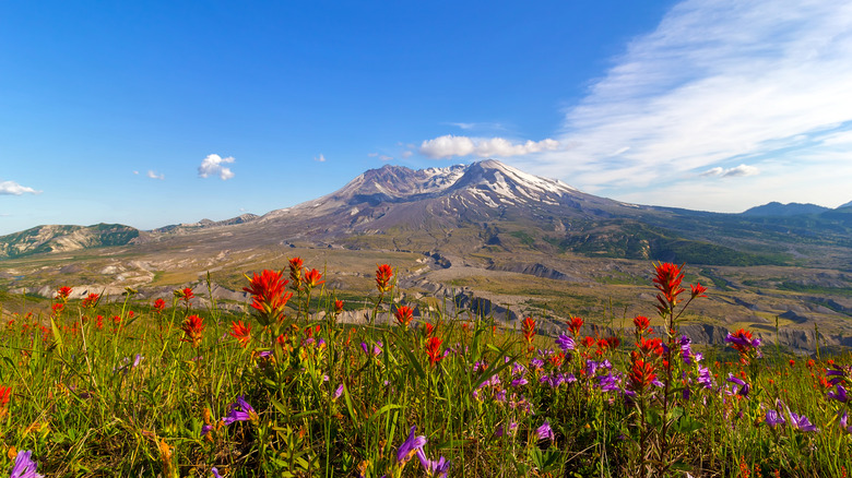
Among the region's top natural wonders is Mount St. Helens in Washington. This National Volcanic Monument stands out as a unique hiking destination blending the raw geological power of volcanoes with the breathtaking scenery of the PNW. Located in Skamania County, this active stratovolcano is about a 3.5-hour drive from Seattle, Washington or 1.5 hours from Portland, Oregon. It's best explored by car during the summer when trails are snow-free and the summit is accessible without technical climbing and mountaineering skills.
The mountain's eruption in 1980, triggered by a 5.0 magnitude earthquake, unleashed a massive landslide and explosion that leveled the surrounding forests, created new lakes, and carved a horseshoe-shaped crater on its summit that reduced its height by 1,700 feet. This disastrous event transformed the landscape into a unique combination of volcanic scars, wildflower-filled meadows, and turquoise lakes, inviting hikers to explore a place where nature's resilience is on full display.
Scenic hiking trails around Mount St. Helens
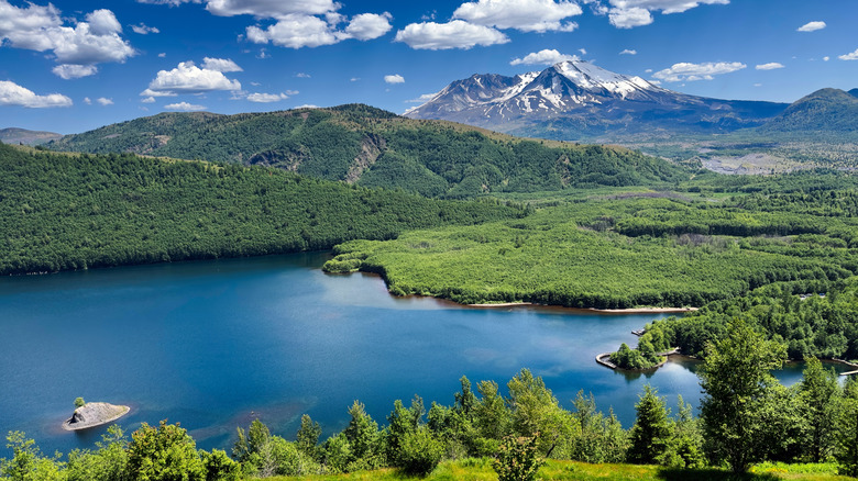
The trails of Mount St. Helens had an opportunity to be almost entirely reimagined and reborn after the 1980 eruption. They offer hikers a chance to walk through a landscape where nature is rewriting its story. The Hummocks Trail, a 2.3-mile loop, winds past ponds and showcases regenerating plants and wildlife on the west side of Mount St. Helens, where the eruption's blast has made a lasting impact. For a longer adventure with stunning views, the Lakes Trail is 9-miles round-trip and leads to a serene lake formed in the eruption's wake. This lake can only be reached by hiking and is framed by wildflowers and pumice plains that provide viewing opportunities directly into the crater.
On the east side of the mountain, nature remains less scarred by the eruption. This area preserves ancient forests and tranquil lakes. The paved 1.3-mile Meta Lake Trail is perfect for families and connects to a quiet lake where kids can explore the calm waters safely. For a more immersive trek, the Norway Pass Trail is a 4.4-mile round-trip trail through colorful wildflower fields to reveal stunning views of Mount Rainier, Mount Adams, Mount Hood, and Spirit Lake, with an option to extend the hike and summit Mount Margaret.
The south side of the mountain has been shaped by lava flows, and one of the most popular paths is the June Lake Trail. Just under 3 miles, this is a family-friendly hike where you can spot a waterfall off in the distance. Alternatively, for the ultimate challenge, determined hikers can take the 32-mile Loowit Trail that circumnavigates the mountain and gives a comprehensive look at this incredible volcano. It usually takes three days to complete.
Exploring Mount St. Helens caves
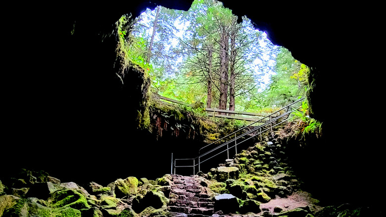
Mount St. Helens offers more than just trails — it's also a place where hikers can dive into geological wonders and educational experiences. The Ape Cave is a 2-mile-long lava tube (considered the third-longest in North America) and is available for exploration. This thrilling underground adventure invites visitors to navigate their way through dark, rocky passageways to marvel at the volcanic forces that shaped them. The caves are open seasonally, require reservations, and maintain a chilly 42°F, so pack a sweater and a headlamp! For another adrenaline rush, visitors can explore the Lava Canyon Trail that crosses a suspension bridge and descends a 30-foot ladder into a gorge carved by the lava flows, with a nearby waterfall gushing to add to the thrilling adventure for hikers who dare to tackle it.
If you are eager to learn about Mount St. Helens, the eruption, and the geology of the area, the monument's visitor centers offer a deep dive into history. The Forest Learning Center and Johnston Ridge Observatory offer interactive displays and films that detail the 1980 eruption's impact and the ongoing rebirth of the ecosystem. You can also learn why the mountain was called Louwala-Clough, or "smoking mountain," by generations of Indigenous communities.