What It Takes To Hike And Summit The 5 Tallest Mountains In The Contiguous US
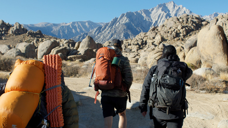
Dreams of outdoor adventures can often lead us to some of the wildest and most remote corners of the world, from scuba diving colorful coral reefs to trekking iconic routes like the Pacific Crest Trail, or bagging your first 14er (a summit above 14,000 feet). For many outdoor enthusiasts, seeing majestic mountains during their lifetime is not enough. Reaching the summit of the five tallest mountains in the contiguous United States, consisting of Mount Whitney, Mount Elbert, Mount Massive, Mount Harvard, and Mount Rainier, can spark the fire for endless dreams and are must-visit destinations for avid hikers.
These peaks range from 14,411 to 14,505 feet and offer an exciting spectrum of challenges, from strenuous day hikes to technical mountaineering accomplishments. Each mountain demands preparation, from battling altitude sickness on Whitney's switchbacks to mastering glacier travel on Rainier's frosty slopes. Exploring what it takes to conquer these giants in the sky means detailing out trail specifics, permits, safety concerns, and required skills for the summit.
Whether you're a novice hiker or a seasoned peak bagger, these summits promise motivating experiences and a test of grit and determination. All of the following mountains are Class 1, a low-risk hike with well-marked trails, or Class 2, which requires slightly more navigational skills than Class 1 and movement over loose rock and scree. You may encounter altitude sickness on any of the continental United States' five highest peaks, so you should be aware of the symptoms: headache, nausea, vomiting, loss of appetite, fatigue, malaise, dizziness or lightheadedness, trouble with vision, and trouble sleeping. Let's dive into the journey one peak at a time, starting with the highest summit to the lowest, to uncover how to turn high-altitude dreams into reality.
Mount Whitney
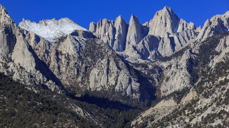
Mount Whitney soars into California's Sierra Nevada skyline, reaching 14,505 feet to claim the honor of the tallest peak in the contiguous U.S. The standard Mount Whitney Trail begins at Whitney Portal at an elevation of 8,300 feet and is 22 miles round trip with a grueling 6,200 feet of elevation gain. Expect to hike for 12-14 hours. The hike is a Class 1-2 hike and not technical during the summer months — the most popular time to summit. It demands the highest fitness and mental stamina, especially at Trail Crest's 99 switchbacks, a notorious struggle for many at 13,600 feet.
Even with the grueling hike, obtaining a permit is usually the biggest hurdle. You can apply for a permit through a competitive lottery system on recreation.gov in February, with 100 day-use and 60 overnight permits issued daily for the May to November season. Only about 28% of applicants end up securing a permit. The trek becomes more technical in the off-season when the route is covered with ice or snow, requiring more gear and skills.
Acclimating at 8,000 feet or higher during your training or even just a few days before your summit push can help you avoid altitude sickness and make or break your success. There are simple steps to prepare for a long-distance hike, such as finding one that mimics Whitney's 500-feet-per-mile grade. Advice is also given to start before dawn, create realistic checkpoints along the route, and carry water and a purifier to refill bottles at streams. Proper training and preparation can lead to success on this beast, as it requires a lot of grit.
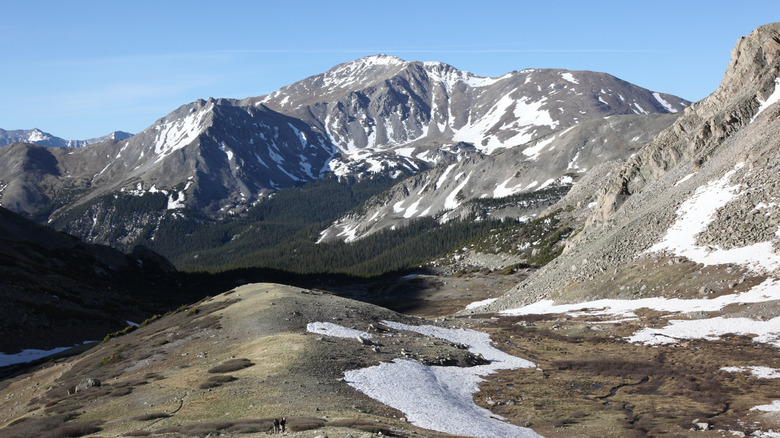
Mount Elbert
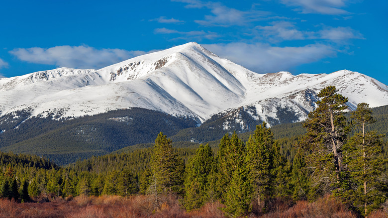
Mount Elbert is Colorado's highest peak at 14,433 feet. It looms over the Sawatch range and offers a manageable but rewarding 14er experience for the determined. The North Elbert Trail starts at 10,066 feet near Leadville and covers 9.3 miles of trail round trip with 4,400 feet of elevation gain. It's a Class 1-2 hike and isn't technical, but rather steep. It averages about 1,000 feet of elevation gain per mile, which is twice as much as Whitney! The most popular time to summit Elbert is during the summer from June to September when trails are clear of snow and the weather provides the best window.
No permits are required to hike Elbert, but parking spaces do fill quickly, and this could be your biggest challenge outside of the elevation per mile gains. Altitude sickness is also of concern, so it's best to acclimate by sleeping above 7,000 feet for a few nights prior to the summit push. Starting early is also advisable to avoid any afternoon storms, which are common on the mountain.
If you're preparing in Colorado, train with hikes like Bear Peak or Mount Audubon, which both require over 4,000 feet of elevation gain. Make sure to check out these strategies for staying hydrated and pack layers and sun protection, as the treeless summit exposes hikers to intense sun and wind exposure that can lead to altitude sickness. Elbert's gradual profile makes it accessible and a favorite for 14er beginners, but it has many false summits that will test the mental fortitude of hikers.
Mount Massive
Mount Massive is Colorado's second-highest peak at 14,428 feet. It dominates the Sawatch Mountain Range with five summits and a 3-mile ridge line all above 14,000 feet. Massive's vast summit area is larger than any other in the lower 48 states. It offers incredible sweeping views. The Main Ridge Trail starts at 10,050 feet, and stretches 13.6 miles roundtrip covering 4,370 feet of elevation gain. This Class 1 route is straightforward but long, though less crowded than Mount Elbert. The West Couloir Route is a shorter but steeper 9-mile Class 2 option that requires more navigation skills and strong legs. Trails are most ideal during June through September when the snow has melted and the weather is better.
A free wilderness permit is available at the trailheads and required for hikes, and groups are capped at 15. Afternoon thunderstorms and sun exposure above the treeline demand an early start and a robust plan for sun protection and dehydration. In order to acclimate to the elevation demands, try nearby hikes such as Grizzly Peak to combat altitude sickness. Aim to train endurance with other 4,000 elevation gain hikes, and pack layers for unpredictable weather. This mountain's scale and unique summit features make it a viable 14er for gritty enthusiasts.
Mount Harvard
Mount Harvard reaches 14,420 feet and anchors Colorado's Collegiate Peaks Wilderness in the Sawatch Range. The South Slopes is the standard route starting at the North Cottonwood Creek Trailhead at 9,800 feet, covering 14 miles round trip with 4,600 feet of elevation gain. This is a Class 2 hike and involves lots of talus and scree scrambling near the summit, making it slightly more demanding than Elbert or Massive. Navigating scree and talus can be challenging to stay on trail as well, as it is often moving and sliding rocks. Make sure you are ready for this adventure on uneven terrain at high elevation so you don't hike bonus miles. This adventure usually takes people anywhere from seven to twelve hours, with a true alpine start to beat the afternoon thunderstorms.
A free wilderness permit is required and is obtained at the trailhead. June to September offers snow-free trails, and like most peaks in the Rocky Mountains, thunderstorms are common in the afternoon, so try to summit before noon to make for a more peaceful descent. Aim to acclimate with local hikes to mitigate altitude sickness, and train with long, rocky hikes to prepare for the final boulder-strewn push of the last 2 miles to the summit. Carry enough water and layers for sudden weather shifts that are common in the mountains. Physical fitness and solid scrambling skills are essential for this arduous yet rewarding climb.
Mount Rainier
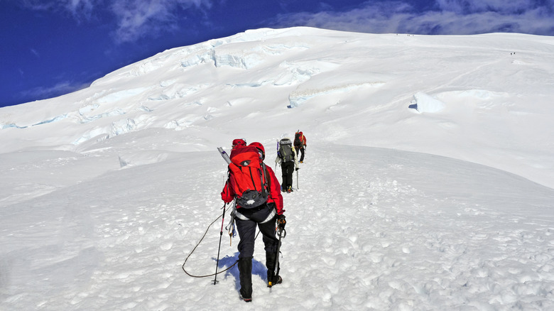
Mount Rainier is Washington State's 14,411-foot crown jewel. This active volcano towers over the Cascade Mountain Range as the most glaciated peak in the Lower 48, comprising 26 major glaciers across its 100-square-mile base. The Disappointment Cleaver Route begins at 5,400 feet, and requires 9,000 feet of elevation gain over the course of 14 miles round trip. This extremely technical climb is best tackled from June to September and requires glacier travel skills, including crampons, ice axes, and roped team navigation skills. It should not be attempted by complete newbies, as the dangers and risks are high on Rainier. Rapid weather changes, including summer blizzards, pose high risks to climbers, to make sure to monitor weather patterns and be ready to retreat if safety is at risk. An annual climbing fee of $70 and an in-person permit from Mount Rainier National Park are required.
Training and preparing for Rainier is much different than the previously-mentioned mountains. Rainier has many hiking trails, but summiting this beast is not a hike, it is an extremely involved mountaineering experience. There are several guide services for novice mountaineers who don't want to commit the time and money required to learn the niche skills. Outfitters also offer introduction to mountaineering courses while summiting Rainier, where climbers can learn the skills necessary to reach the summit under the supervision of experienced guides. Otherwise, those summiting without guides typically have years of experience to fall back on. It has been called the hardest endurance climb in the contiguous United States, and as with any challenging accomplishment, it's sure to be one of the most memorable.