This Is One Of Europe's Most Dangerous Hikes That Social Media Made Popular
It's no secret that Switzerland is a paradise for hikers. Trails can be found all around the country, often tucked between gorgeous mountains and cutting through postcard-worthy meadows. So it comes as no surprise that one of the most popular hikes on the internet would be located right in the heart of the Swiss Alps. The hike is the Hardergrat trail, and you might have seen it before in breathtaking HikeTok clips or viral Instagram reels.
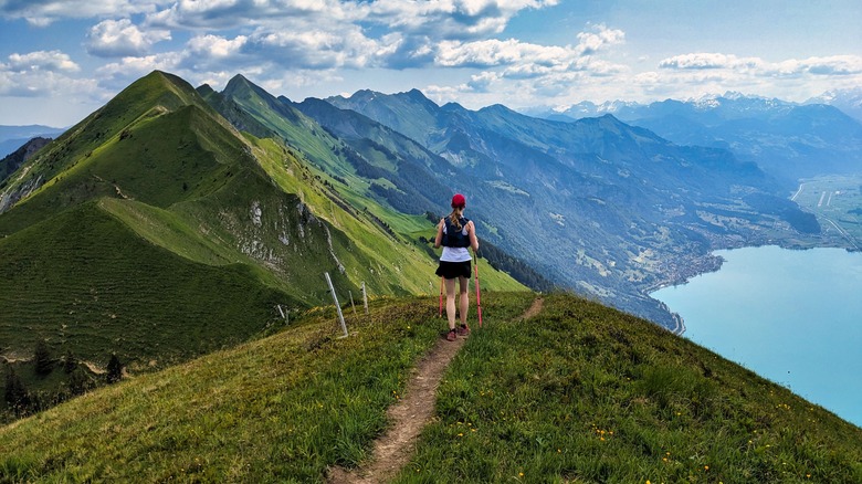
Hardergrat trail stretches 24 kilometers (15 miles) between Interlaken and Brienz, with the majority of the path running atop a sharp ridge that slices the sky like a knife. Like many things seen on social media, it's too dangerous to be repeated in real life — unless you plan your trip carefully and show up prepared for the challenge. Hikers should expect 3,000 meters, or 10,000 feet, of elevation gain during the course and — scariest of all — long sections where one wrong move could mean death.
Hardergrat isn't for casual hikers
A trek to a top-of-the-world view is what every avid hiker dreams of, and you'll get it at Hardergrat. However, the rewarding scenery doesn't come without an element of danger. Those who attempt the ascent end up on a thin trail located high above the clouds with Brienzersee, the region's lake, sitting just below at the mountain's edge. A foot slip could mean a 1,500-meter (5,000-foot) drop into the water on one side or onto the rocky terrain on the other. Given the trail's difficulty, it's earned a reputation as one of the most dangerous in Switzerland. Deaths aren't common, but they do happen. In 2019, for instance, a man tumbled hundreds of meters while traversing the Hardergrat and died from the fall.
Weather plays a crucial role in the safety conditions on the trail. Rain or snow can make the narrow path slippery, which increases hikers' chances of losing their footing and falling off the ridge. Wind, too, can knock a person down or affect their balance, which could also send them tumbling off the side of the peak. Even a clear, sunny day doesn't guarantee conditions will be safe — much of the trail lacks shade, meaning hikers will sweat a lot during the journey. And since there's no access to water at the top, dehydration can be a serious concern for adventurers of all levels.
How to prepare if you decide to hike the dangerous trail

No view is worth risking your life over. That said, experienced hikers may find Hardergrat a doable and only mildly difficult trek. If you plan to join those who have already completed the famous Swiss hike, your first step is mapping out your course. The classic route starts at Interlaken and ends at Brienzer Rothorn Station, with a train ride down to Brienz. However, some hikers choose to reverse the route or do a complete loop, running the length of the trail in a day. If safety is your biggest priority — as it should be — consider starting your trek in Brienz and ending in Interlaken, which saves the easiest hiking trails for last, allowing you to use your strength when it's most needed.
Another alternative, best for poor-weather days or nervous hikers, is a limited version that runs between Harder Kulm and Augstmatthorn. This hike takes about six hours to complete (compared to 10 hours on the longer Hardergrat route) and eliminates some difficult sections. Regardless of your chosen route, don't treat the hike as a light day trip. Instead, come fully prepared with plenty of water, food, and sunblock. Be sure to bring hiking gear, too, including your best hiking boots, poles, and some grippy gloves, since scrambling is required on the trail.