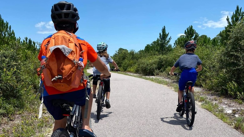
The Most Beautiful Bike Trails Across The US To Add Your To Bucket List
With the rise in distracted driving making biking on the roads increasingly unsafe, avid cyclists are taking to off-road paved trails where they can pedal with less risk. But choosing trail over road offers more than just safety; some of the nation's best recreational bike trails offer stunning scenery, from the Allegheny Mountains to the Gulf Coast.
There are literally tens of thousands of miles of paved trails all over the United States, and a single trail can be hundreds of miles long. Some trails stand out above the rest, taking you through old-growth forests and wild coastline — sometimes several ecosystems in a day — and bringing you up close and personal with wildlife. So grab some friends, hitch up your bike, and get ready to check these top cycling destinations off your bucket list.
Hugh S. Branyon Backcountry Trail
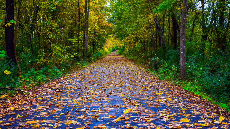
Recently rated the top recreational trail in the United States by USA Today, the Hugh S. Branyon Backcountry Trail has a lot to love. Located in the 6,150-acre Gulf State Park in Alabama, the 28-mile paved trail connects the cities of Gulf Shores and Orange Beach. The trail traverses several distinct ecosystems, including dunes, marshes, swamps, maritime forests, and longleaf sand ridges, which gives riders the opportunity to see a variety of flora, including tall pines and palm trees; squat, dense shrub oaks; cattails; pitcher plants; and fragrant Florida rosemary.
Wildlife also abounds, so keep your eyes peeled for alligators, coyotes, bobcats, white-tailed deer, herons, osprey, and bald eagles. In addition to the trail itself, Gulf State Park has miles of white sand beaches, a nature center and butterfly habitat, a lakeside picnic spot, and a primitive camping area. Visitors can rent bikes for free for up to three hours at a time, thanks to the park's bike-share program.
Banks-Vernonia State Trail
Just outside of Portland, Oregon, the Banks-Vernonia State Trail is a multi-use trail that extends 21 miles through Washington and Columbia counties. The 8-foot-wide paved bike trail is bordered by a 4-foot-wide gravel horse trail, so bikers and hikers should be prepared to share the road with equines and their owners.
Starting from Banks at the south end, the trail maintains a gradual rise of only 2% to 5%, making it accessible for all levels of riders. The only exception is a small stretch at the Horseshoe Trestle bypass consisting of steep switchbacks. Ride through swathes of farmland and forest, catch beautiful mountain views, and traverse rivers and streams by way of more than a dozen bridges, including Buxton Trestle. The trail has five access points, each of which has parking and restrooms. Camping and other recreational activities can be found in the connecting L.L. Stub Stewart State Park.
Cape Cod Rail Trail
The Cape Cod Rail Trail in Massachusetts is a great way to see the small towns and beautiful landscape of the region. The trail extends 25 miles from South Dennis to Wellfleet, passing through the towns of Yarmouth, Brewster, Harwich, Eastham, and Orleans along the way. Stop off at Seymour Pond in Brewster or Flax Pond in Yarmouth for a swim or a picnic on the shady beaches. If you didn't bring your lunch, there are several places to stop along the way for a meal or snack, including Cobie's Clam Shack and Stone L'oven Pizza Company in Brewster. There's even a winery in Harwich to stop, sit, and sip a while.
Nickerson State Park in Brewster has a lake, hiking trails, and hundreds of campsites. There's also a yurt for those who don't want to BYOT (bring your own tent). Be aware that there is one slightly complicated section of trail after mile marker 12 where you'll need to exit the trail and ride a stretch of road. You'll cross over an overpass and turn left on Salty Ridge Road then hook up with the pathway again.
Great Allegheny Passage
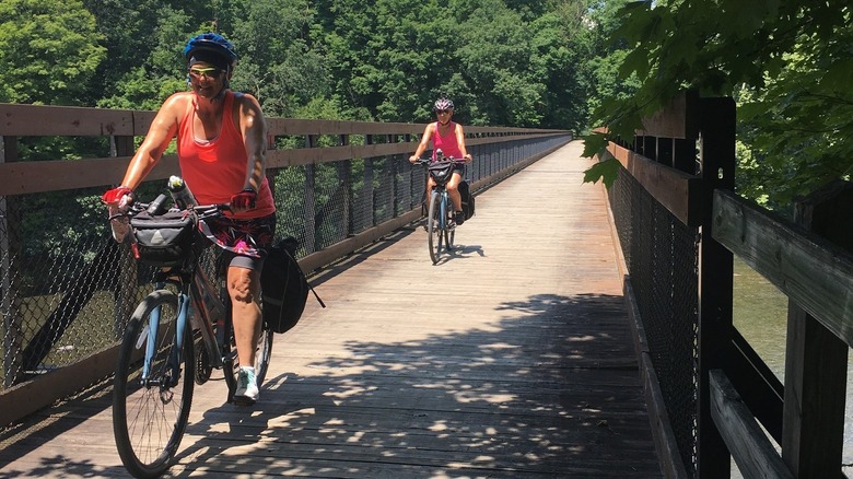
If you're up for a challenge, go the distance on the Great Allegheny Passage trail — all 150 miles. Extending from Cumberland, Maryland to Pittsburgh, Pennsylvania, the trail passes through many towns along the way. You'll never be far from a pit stop, a bite to eat, or overnight lodging. The trail surface is primarily crushed limestone, except for a few paved sections. It's an easy trail, gaining a maximum of 1,767 feet with a relatively gradual rise.
For an even longer ride, the Great Allegheny Passage connects with the C&O Canal Towpath, taking you through several towns in Maryland and West Virginia before reaching Washington, D.C. Whether you do one or both trails, you can catch Amtrak's Capitol Limited train from several of the bigger towns along the way to take you and your bike back to your starting point.
Virginia Creeper Trail
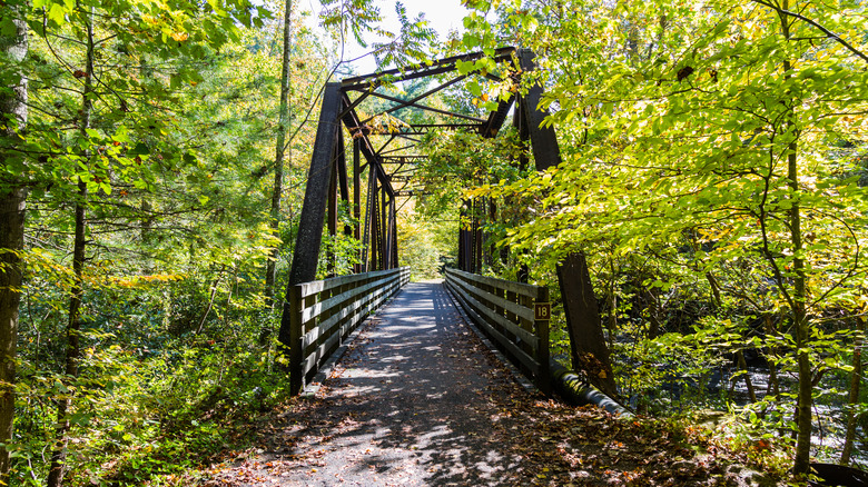
The Virginia Creeper Trail offers a relaxing or challenging ride, depending on which direction you choose to go. Start at Whitetop Mountain Station at an elevation of 3,500 feet, and coast about 34 miles to the trail's end in Abington, or start in Abingdon and pedal uphill to Whitetop. Either way, you'll get stunning views of mountains, farmland, and forests. Dozens of wooden trestles cross over streams and creeks, including Whitetop Laurel Creek, one of the state's largest wild trout streams.
If you don't want to do the full trail, there are many access points along the way. And if you're renting bikes, bike shops will typically shuttle riders to the trail. Pack your own trail picnic or stop along the way at trail-adjacent cafes and ice cream shops. Stop overnight at the towns of Damascus or Abingdon, which offer plenty of lodging options, or set up camp anywhere along the way on public land. The USDA Forest Service asks that campers choose a campsite away from the trail and not on streams or rivers.
Ke Ala Hele Makalae
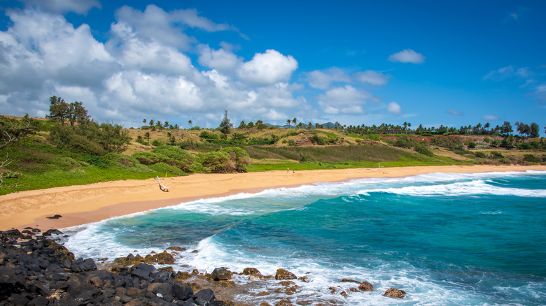
Hawaiian for "the path that goes by the coast," Ke Ala Hele Makalae hugs Kauai's eastern coast from Ahihi Point to Lydgate Park for 7.3 paved miles of ocean views for lucky bikers, hikers, and joggers. A mixture of rocky shoreline, beaches, parks, and residential areas offer opportunities for exploration and a swim along this mostly flat trail. Whales can be seen off the coast in winter, and dolphin pods in summer. Interpretive signs at frequent intervals provide details on the area's history, including its old coconut groves and pineapple plantations.
Lydgate Park has two protected lagoons for safe swimming and snorkeling, and there are campsites for sleeping under the stars. Shops in Kapaʻa Town rent bicycles, and restaurants and facilities can be found nearby many points on the trail.
Chuck Huckelberry Loop
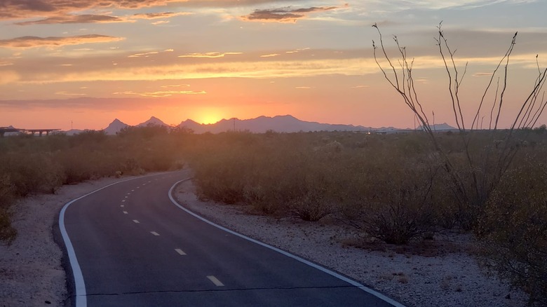
Named for a county administrator who lobbied for its construction, the Chuck Huckelberry Loop is a 131-mile trail around Tucson. Its location makes it easy to access, with multiple trailheads around the city offering parking and facilities. From the trail, you can explore several of the city's highlights, including the Cañada del Oro Wash, Pantano Wash, the Santa Cruz River, and Rillito Creek. Stunning views of the mountain ranges surrounding Tucson can be enjoyed from any point along the trail.
Hop on a bike to browse a farmer's market or grab a coffee or a bite at any one of the commercial districts along the trail. And don't miss the outdoor art installations, such as the "Joining Hands" arch across the Julian Wash. You can rent bikes at many shops near the trail, and you can also use Tuscon's Tugo bike share program for convenient access to bikes at kiosks throughout the city.
Trail of the Coeur d'Alenes
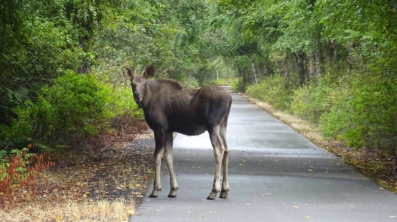
The U.S. Government, the state of Idaho, the Coeur d'Alene Tribe, and the Union Pacific Railroad came together to build the Trail of the Coeur d'Alenes, a spectacular 73-mile multi-use trail winding through northern Idaho. Connecting the city of Mullan near the Montana border and Plummer near the Washington state border, it passes through Silver Valley, the Chain Lakes and Lake Coeur d'Alene areas, Heyburn State Park, and the Palouse Prairie. Along the way, riders have the opportunity to explore several small towns, including historic Wallace and Harrison.
The trail is also a great place to spot some of Idaho's diverse wildlife, including moose, white-tailed deer, elk, coyotes, river otters, beavers, and muskrats. One of the most popular sections is between Harrison and Heyburn, where the trail traces the Lake Coeur d'Alene shoreline, then traverses the 3,100-foot-long historic Chatcolet Bridge constructed in 1921. The bridge ends at Heyburn State Park, where you can hike, boat, swim, and camp or rent a cottage or cabin.
Swamp Rabbit Trail
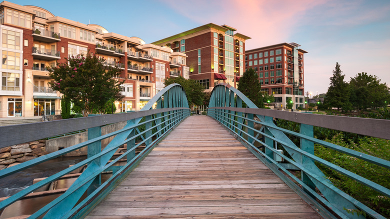
The Swamp Rabbit Trail has a prime location starting near downtown Greenville, South Carolina, making it more accessible than some of the other options on this list. Named for the native swamp rabbit species, the trail primarily follows an old railroad bed along the Reedy River through Greenville to the neighboring city of Traveler's Rest. Many of Greenville's top attractions are linked by the trail, offering an opportunity to see the city by bike.
Be sure to visit one of Greenville's most popular sites, Falls Park on the Reedy, where you can cycle across the single-suspension Liberty Bridge and gaze down at the Reedy River Falls. The trail also connects to Cleveland Park, Furman Lake, the Children's Garden at Linky Stone Park, and Greenville Zoo. You can take a tour of some of Greenville's top restaurants by bike, including The Lazy Goat and the Swamp Rabbit Cafe & Grocery. If you're more thirsty than hungry, stop and sip at Birds Fly South Ale Project or the Swamp Rabbit Brewery & Taproom.
Katy Trail
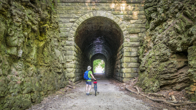
Clocking in at just under 240 miles, the Katy Trail in Missouri is the longest recreational trail on our list. Spanning almost the entire state from Clinton in the west to Machens in the east, the Katy Trail primarily traces the Missouri River. The portion of the trail between Cooper County and St. Charles County is part of the Lewis and Clark National Historic Trail, and the Katy Trail connects with the American Discovery Trail in St. Charles.
With virtually no elevation gain and a surface of hard-packed crushed limestone, this is an easy trail for any level of rider. You'll want to make time for a lot of stops along the way, including the towns of Defiance, Augusta, Rocheport, and Sedalia, all of which offer opportunities for dining, lodging, and shopping. In Defiance, visit the Historic Daniel Boone Home, stop off at the Lake Creek Winery in Marthasville, and visit the Daum Museum of Contemporary Art in Sedalia.
Colorado Riverfront Trail
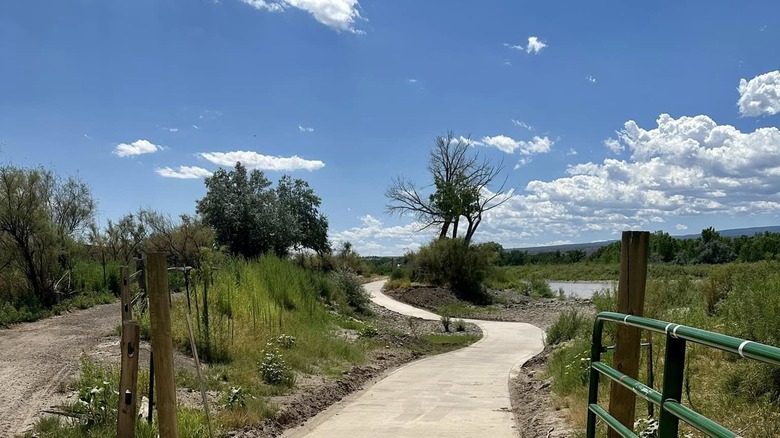
The Grand Valley of western Colorado provides a majestic backdrop for the Colorado Riverfront Trail. As its name suggests, the 22-mile trail is located along the Colorado River and takes riders through the towns of Fruita, Grand Junction, and Palisade.
The trail is made up of several distinct sections. At the western end is the Monument View section, where the jagged peaks of the Colorado National Monument rise up in the distance. The Riverside section takes you to the Western Colorado Botanical Gardens and Butterfly House. When it's time to rest, the James M. Robb – Colorado River State Park offers places to camp and opportunities for fishing, birding, and boating.
The Presidio
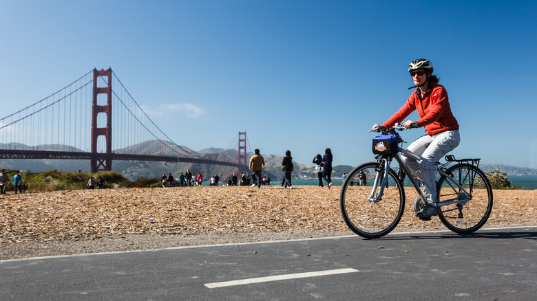
The Presidio of San Francisco is a gem of the Bay Area located on the tip of the San Francisco Peninsula and part of the Golden Gate National Recreation Area. The area encompasses 1,500 acres of beaches, forests, and a lake, as well as 25 miles of interconnected recreational biking and hiking trails taking you to important sites in San Francisco, one of the best U.S. cities for history buffs to add to their bucket list. Take a leisurely ride around Chrissy Field, which offers view upon view of San Francisco Bay and the Golden Gate Bridge. You can stop to rest on the beach, have a picnic, or grab a coffee and a snack at the Warming Hut Park Store.
Next, stop off at the Lettermen Digital Arts Center, the San Francisco National Cemetery, and the Fort Point National Historic Site. Get up close and personal with the Golden Gate Bridge by riding straight out to the tip of the peninsula. From there you can ride over the bridge and back, or you can continue on towards Sausalito where you can return via the Golden Gate Ferry.
C&O Canal Towpath
The C&O Canal was constructed over more than two decades in the 19th century as a route for transporting coal. However, by the time it was complete, railroads became the preferred mode of transportation making it obsolete. It lay dormant for many decades until it was declared a national park in 1971. Today, it's a favorite spot for recreation in the Washington, D.C. metro area.
Stretching 184 miles from Georgetown in D.C. to Cumberland, Maryland, the trail is surrounded by parkland offering plenty of opportunities for hiking, boating, camping, and touring historical sites along the way. The historic canal towns located at frequent intervals offer places to eat, sleep, and learn about the history of the area. Poolesville, Maryland; Harpers Ferry, West Virginia; and Shepherdstown, West Virginia are among the most popular stopovers. Other sites along the canal include the Abner Cloud House and Mill, which is among the oldest buildings along the canal; Anglers, where you can hike the famous Billy Goat Trail; and Cushwa Basin, where you can see a railroad lift bridge.
George S. Mickelson Trail
Rock tunnels and dozens of railroad bridges are a highlight of the 109-mile George S. Mickelson Trail in South Dakota. Connecting the towns of Deadwood and Edgemont, the trail winds its way through the Black Hills, in and out of ponderosa pine forests, through high mountain meadows and vast prairies, and over creeks and streams.
Scenery changes from rugged mountains to open farmland provide a diversity of landscape and wildlife, including elk, turkey, mountain lions, foxes, and coyotes. Explore small trail towns along the way, where you can grab a bite, find a bed, or learn the unique history of the old railway communities. While most of the trail is relatively easy, be aware that there are portions that are more demanding, particularly the stretch between Deadwood to Dumont.