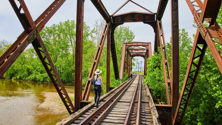
Ride The Best Rail Trails In America
When both freight and passenger rail services began to dwindle across the U.S., vast tracts of land were left abandoned and falling into disrepair. More recently, however, thanks to the passion and expertise of nonprofit organizations such as the Rails-to-Trails Conservancy, there has been a drive to turn these unused corridors into multi-use trails for walking, running, cycling, and horseback riding. There has been a huge amount of investment in developing the disused railroad beds and the areas along the old lines, and many have been repurposed and reimagined into beautiful public spaces.
Today, you can enjoy nearly 25,000 miles of converted rail trails across the country to hike or ride over restored bridges and sky-high trestles, as well as through mountain tunnels and forests. These repurposed pathways offer some of the best hiking across the U.S. Ranging from hundreds of miles to just a few, these varied rail trails allow visitors of all ages and abilities to experience some of the most amazing scenery in the U.S. from a different perspective, whether on foot, horseback, or two wheels.
Olympic Discovery Trail
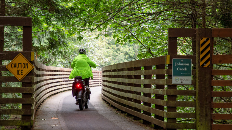
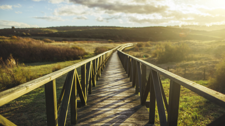
Spanning 130 miles, from Port Townsend to La Push, the Olympic Discovery Trail is a unique way to immerse yourself in the diverse, stunning landscapes that the Olympic Peninsula is so famous for. This multi-use path — that follows the route of the abandoned Milwaukee Railroad Corridor – is suitable for hiking, biking, and horseback riding. There are 90 miles of rail trail dedicated to non-motorized vehicles at present. Using restored railway trestles and bridges, the Olympic Discovery Trail winds its way through farms, fields, and charming towns, as well as a dramatic mix of rivers, ravines, forests, and the snow-capped peaks of the Olympic Mountains.
The most adventurous riders and hikers will want to traverse the entire route, from the Puget Sound to the Pacific Ocean, riding westward from the waterfront at Port Townsend. You can arrive by car, ferry, or bus from Seattle (the Dungeness Line can accommodate bikes), and then take advantage of the camping and lodging facilities available in the towns that you pass along the way, such as Port Angeles and Forks.
There are also four distinct sections — East End, East Central, West Central, and West End — that are perfect for day trips or shorter rides. The West Central segment, from Port Angeles to Fairholm Hill, is one of the most exciting. Running parallel to the Strait of Juan de Fuca, the trail crosses the Elwha River on a suspended bridge and then climbs to the shores of a glacial lake.
Virginia Creeper National Recreation Trail
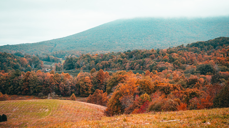
Situated on the southwestern border of Virginia, where it meets Tennessee and North Carolina, the Virginia Creeper Trail lies along 34 miles of retired rail bed. It has a smooth, hard-packed surface of dirt, cinders, and crushed limestone — leftover from its days as a working railway. With gentle grades and a compact surface, the trail is suitable for all abilities, whether hiking, cycling, or horseback riding.
It passes through the beautiful scenery of Mount Rogers National Recreation Area, Virginia's highland country, and the Jefferson National Forest along the Laurel River, providing some incredible views all year round. However, it's particularly popular during the fall, when the route is transformed by the bright array of oranges, reds, and yellows of the deciduous leaves. The Virginia Creeper vine — which inspired the trail's name, and is visible from the path — becomes an especially vibrant yellow at this time of year.
The rail trail runs from Whitetop to Abingdon, but most users actually begin their journey at the town of Damascus, which lies at its center. This is because it has excellent facilities, offering a base for an overnight stay or a meal after your ride, as well as bike rental and shuttle buses up to the trailhead at Whitetop. Whitetop stands at the highest elevation along the trail, so you can glide downhill all the way to Damascus as you enjoy the sights — the perfect introduction to rail trails for beginners.
George S. Mickelson Trail
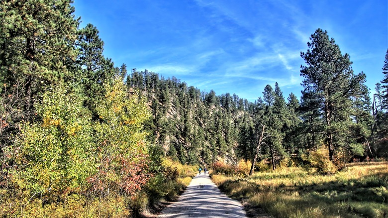
Winding its way through 109 miles of Dakota's Black Hills, the George S. Mickelson Trail connects Deadwood with Edgemont. This exciting route takes you across more than 100 converted bridges, through four rock tunnels, and miles of stunning spruce and ponderosa pine forests. The surface is mostly crushed limestone and gravel, with some sections of the trail cut right into the mountainside, and you can enjoy it through all weather and seasons. A popular trail for bikers, runners, and equestrians, the trail is also great for skiing in the winter. Following the route of the historic Burlington railway, you can still catch a glimpse of the area's busy past transporting people, freight, and animals through gold mining country, such as old signs and forgotten railroad ties. There are also information boards offering insights and explanations along the way.
Because the pathway covers so much ground, there are some parts that are suitable for beginners and families, even though other sections are much more strenuous, with steep drop-offs, long climbs, and narrow spaces crammed up against the granite mountain walls – ideal for experienced bikers and hikers seeking a challenge. To make the beauty of the Black Hills accessible for all, however, there are also trolley rides and talks, which are held on different segments of the trail throughout the year, for visitors with limited mobility.
Route of the Hiawatha
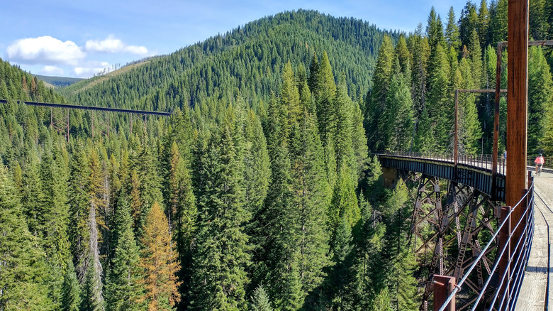
Route of the Hiawatha is one of the best rail trails in the U.S. for novice hikers and families with younger children. Beginning on the Idaho-Montana state line, this biking and walking trail winds its way mostly downhill for 15 miles. There's bike rental available at nearby Lookout Pass Ski Area (including helmets and lights, which are necessary inside the tunnels), as well as an optional return shuttle service that will deliver you back to your car if you don't want to peddle back up the hills. But, although the gradient and shorter length make this an easy ride, Route of the Hiawatha is far from ordinary — it passes across seven spectacular high trestles and through 10 tunnels, including the 1.66 mile-long St. Paul Pass Tunnel, also known as the Taft Tunnel.
When it was in operation, it was lauded as one of the most scenic stretches of railroad in the country, and when you're breathing in the crisp mountain air, it's easy to see why. Crossing the Bitterroot Mountains, the trail meanders past beautiful waterfalls (look out for the one at the West Portal of the Taft Tunnel, in particular) and rugged terrain. The trailhead is located at the tunnel's East Portal, although you can also walk or cycle from the Lookout Pass parking lot if you would like to extend the ride by another 10 miles.
Banks-Vernonia State Trail
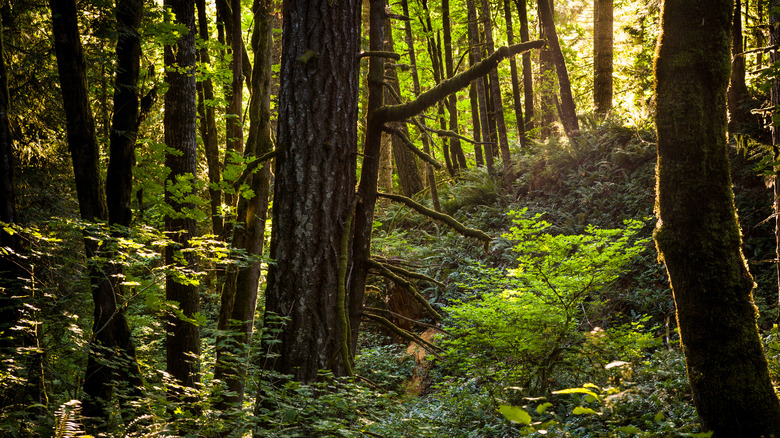
Crossing through the hills between the two towns for which it is named, the Banks-Vernonia State Trail runs along a former timber railroad corridor that conveyed wood from the mills of Vernonia to Portland. It consists of a wide hiking and biking path alongside a separate horseback riding one. Although only 21 miles long, it is considered to be one of the more challenging and interesting U.S. rail trails. Experienced bikers will love the varied terrain and the drama of the switchbacks and climbs. There are also 13 bridges and two high trestles — one at Buxton and another at Horseshoe — to cross, all of which afford visitors incredible views over the Oregon Coast Range.
You can explore the full route over two days, stopping off to camp or rent a rustic cabin midway at L.L. Stub Stewart State Park to make the most of the beautiful natural setting, or choose a shorter section to complete on a day trip. There are multiple entry points along the trail, including in Vernonia, Buxton, Manning, and Banks. Vernonia, the trail's endpoint, is also well worth a visit. This quaint pioneer town is known for its independently owned shops and charming bed and breakfasts.
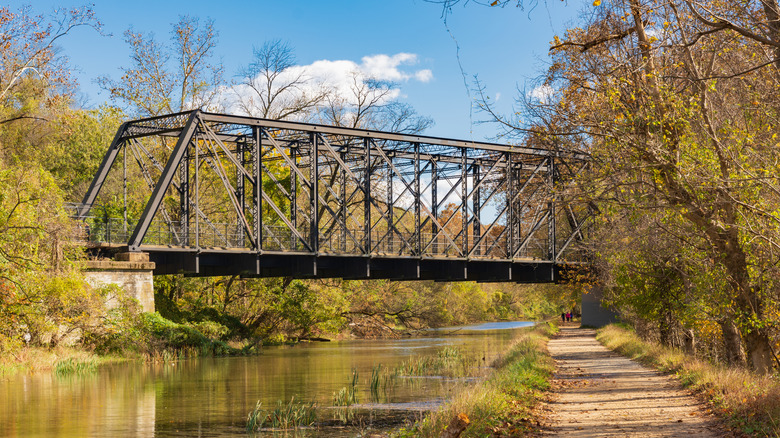
Torrey C. Brown Rail Trail
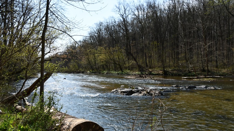
Situated along the former Northern Central Railway (NCR) line, and easily accessible from Baltimore, this popular Maryland rail trail is one for history lovers. You can learn all about the past of the railroad, which provided a vital link between Baltimore and New York for more than a hundred years, at the museum and visitor center located in the old Monkton Station. The town of Monkton flourished when it became an important stop along the railway line, and it is now the most popular access point to the rail trail. Today, the Torrey C. Brown Trail — named for a former Department of Natural Resources Secretary who was an important advocate for its conversion into a mixed-use trail — has 19.7 miles of crushed-stone paths that take you north from Ashland to the Pennsylvania state line.
A few miles from Ashland, you will arrive at the Sparks Bank Nature Center, which is open to visitors in the summer and has interpretative displays about the local wildlife and birds that can be spotted in the area as you enjoy your ride or hike. The route then runs through Gunpowder Falls State Park, winding along the picturesque river valley. Here, you can take a dip in the cool waters of Gunpowder Falls. This trail isn't just popular with cyclists and walkers; in hot weather, swimmers and city residents carry inner tubes down it, ready to float away along the southern section of the river.
Great Allegheny Passage
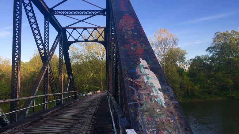
A long-distance hiking trail, the Great Allegheny Passage provides a vast area to explore — stretching 150 miles from Cumberland in Maryland to Pittsburg. It's ideal for walkers and cyclists who want to take their time to discover the area and enjoy a longer vacation. The rail trail connects several towns and points of interest, such as Mayersville and Connellsville, on its way through the mountains of Maryland and Pennsylvania's Laurel Highlands, and they are all accessible by bike or on foot directly from the trail.
As the crushed stone and paved surfaces are smooth, and the path mostly goes around or through the mountains rather than climbing over the top of them, it's an ideal destination for family holidays. The gentle gradients also make this trail popular with inline skaters, especially along the Monongahela River. The trail crosses viaducts, 30 bridges, and the deepest gorge in Pennsylvania as it heads north. In addition to the natural beauty and mountain vistas, it's a hub of interesting art and architecture, and you can look out for such sights as the unique Connellsville Gateway Arch and the murals and mosaics of Pittsburgh's South Side.
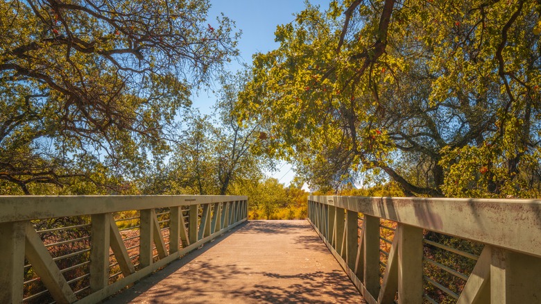
Kokosing Gap Trail
Built on a restored section of the Pennsylvania Railroad line that runs from Mount Vernon to Danville, Ohio, this paved recreational path is just 14 miles long, but offers a quintessential rail trial experience — perfect for those seeking their first rail trail adventure. Kokosing Gap Trail crosses the Kokosing River on two bridges and winds its way through a scenic mixture of villages, forests, farmland, and wetlands, offering a variety of sights and amenities in addition to the peace, quiet, and shade along the waterway.
Families will love the Rotary Park playground at the Howard underpass and the butterfly garden at Kenyon College Brown Family Environmental Center, which directly adjoins the Kokosing Gap Trail. You can also learn about the railway's history on information boards scattered along the route. However, the highlights of this trail are the vintage locomotive and bright red, wooden Chesapeake & Ohio caboose. They were both fully restored with the help of funds raised in the local community, and are now situated beside the path at the site of the former Gambier Station, providing visitors with a unique glimpse into the past. You can even climb aboard and ring the bell for a taste of a bygone age.
Historic Union Pacific Rail Trail
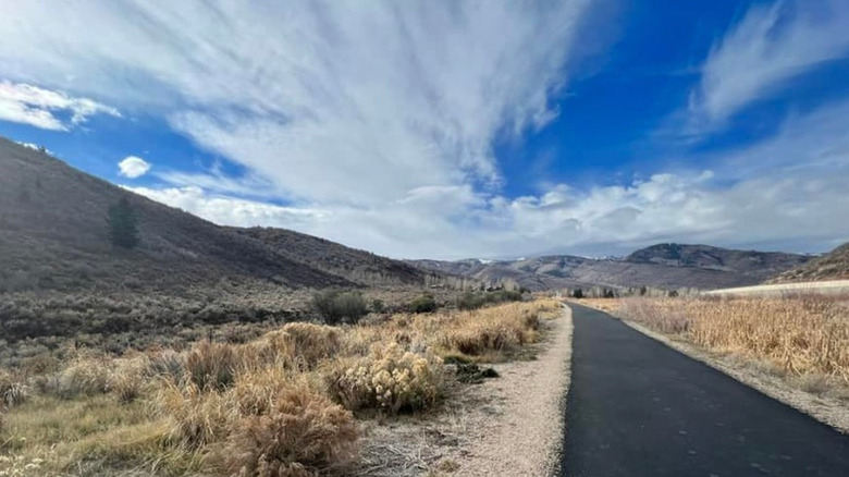
The first rail trail to open in Utah, the Historic Union Pacific Rail Trail follows two former narrow gauge railway lines that transported coal and silver during this area's busiest mining periods. Laid out over 28 miles, the route traces a path from the base of the Wasatch Mountains at Park City to the Weber River, terminating at Echo Reservoir. It passes through some of northern Utah's most picturesque scenes, from rolling farmland to the wetlands of Silver Creek Canyon. You can marvel at the landscape and wildlife as you pass, such as moose and bald eagles on the plains, as well as beaver dams and leaping trout in Silver Creek — or pause to read about Ice Age mammoths, Mormon settlers, and the silver industry on one of the informative plaques along the route.
From the Park City trailhead, the first few miles of the route are paved, offering access to inline skaters, skateboarders, and wheelchair users. The rest of the path has a gravel surface that's suitable for biking or hiking at every ability. For a more challenging day, there are a number of high-intensity rides linked to the main trail that experienced bikers can take off-road through the Wasatch Mountains. The Historic Union Pacific Rail Trail is open all year round and is often blanketed in snow during the winter months — at this time of year, it's the alpine skiers who take advantage of the stunning views here.
Capital Crescent Trail
Connecting the capital city with the leafy suburbs of Maryland, the Capital Crescent Trail is the perfect way to get a different perspective of Washington D.C. Much of the trail is wooded and peaceful — to the extent that it would be very easy to forget that you're actually walking or pedaling through one of the busiest and most important urban areas in the U.S. — but it also offers unique views over some of Washington D.C.'s best memorials and highlights, including the Washington Monument and the Potomac. It traces the historic route once taken by the Baltimore and Ohio Railroad, which carried coal for Georgetown's street cars, and even limestone for the construction of the Lincoln Memorial.
Starting out in Georgetown near the Watergate Complex, it passes through the Dalecarlia Tunnel on its way to the popular neighborhood of Bethesda. Be sure to look out for the unusual person-size cutouts in the tunnel's sides, which were used if a pedestrian needed to get out of the way of a passing train! This section of the path, closest to the city, is used for commuting as well as recreation, which makes it one of the most heavily trafficked rail trails in the country. Further along, however, as it reaches the banks of the C&O Canal Towpath, the crowds disperse while peace and quiet descends. To escape into the countryside, you can ride along the canal for up to 185 miles to Cumberland, Maryland.
Sacramento River Rail Trail
One of the premier rail trails in the Western U.S., this hidden gem offers incredible views over rivers, reservoirs, hillsides, and woodlands. Sacramento River Rail Trail consists of 11 miles of paved path that begins at the southern trailhead at Keswick Dam and passes around the Western edge of Keswick Reservoir. The water is bright and clear, capturing the icy waters released from Shasta Lake. Once the route of the Southern Pacific Railroad line that connected California with the Pacific Northwest, there are interesting sights to be found in every direction — a tall tower at Matheson, for example, which marks the remnants of an old mining tramway. You'll also pass through a 1923 tunnel on your way north to the trail's end at Shasta Dam, one of the largest dams in the country.
Alternatively, to extend your ride or walk, you can take one of the trails along Iron Mountain Road or connect to the Sacramento River Trail near Keswick Dam and then head south to the charming town of Redding. Here, you can cross the river via the famous Sundial Bridge — a soaring glass structure that was designed by a renowned Spanish architect and has artistic lighting that sets off its dramatic beauty at sundown each day.
Empire State Trail
Finally, no list of the best rail trails in the U.S. would be complete without the Empire State Trail — an epic 750-mile paved and packed trail that was completed in 2020. It stretches all the way from the urban streets of Manhattan through the Hudson River Valley to Albany, then west to Buffalo along the Erie Canal, and northwards to the Champlain Valley and Adirondacks. The longest rail trail in the country, you can even ride all the way to the Canadian border on its northern branch.
There are a number of diverse lodging options, from campsites to B&Bs to resorts, situated along the way for those who want to tackle part or all of its length on a multi-day vacation. However, it is also possible to dip in and out of its pleasures, enjoying the sights of New York State on a day trip for a shorter walk or ride. There are a number of distinct sections along the Erie Canalway or the Champlain Valley Trail in Albany that work well for this purpose, and the path is accessible and rarely steep, so visitors of all ages and abilities can enjoy the route. There are also hundreds of breweries, wineries, and distilleries to explore within 10 miles of the trail. You can even grab an official Empire State Trail craft beer map and passport, where visitors collect stamps at each establishment they visit along the way.