The 15 Best Stops To Make On Your Trip Along Australia's Great Ocean Road
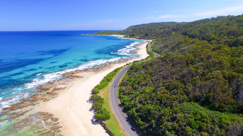
Skirting the cliffs and bluffs that line the coast of southeastern Australia, the Great Ocean Road (or B100 as it is officially labeled) is a stretch of tarmac that truly lives up to its name. The route, which traces the Southern Ocean as it heads east-west in a vague V-shape, isn't extravagantly long — at 243 kilometers, or about 145 miles, it could conceivably be covered in a day. But the distance it extends isn't the point, and rushing to get from one end of this arterial wonder to the other end would be a travesty. Between the two terminals of this iconic road — Allansford in the west, Torquay in the east — lies a vast collection of rousing sights, from pretty broad beaches to forests and quaint villages.
This is definitely a road trip where the journey, and the many stops within it, are as important as the destination. The Great Ocean Road is a fabulous adventure all year round, but to really get the most out of the natural wonders that you'll encounter, visit when it's dry and clear, which means summer temperatures (December through February), but also crowds. Most people ride the road from east to west, since they fly into Melbourne, close to Torquay, so this guide is arranged in that direction. But you could easily drive to Allansford from Melbourne via inland roads (it takes about three hours) and complete the drive in reverse. In which case, start at the bottom of this list and work your way up.
Bells Beach
As you kick off your three-day (or more!) journey from Torquay, your first stop of mention is Bell's Beach, which happens to be a huge draw for surfers, For some, it's thought of as the epicenter of the Australian surfing scene. The scenery is certainly dramatic, with vertiginous cliffs that seem to beckon rolling waves and swells produced by the Southern Ocean.
It's a tough surfing spot, not for the faint-hearted, but is of such importance that it has been added to the state's heritage list. The Bells Beach Surfing Recreation Reserve is praised for its consistent waves, formed as the swells break over reefs in the shallows, with the shoreline formation turning the water environment into an amphitheater. The first surfing competition was held here in 1961 and continues today, now known as the Rip Curl Pro Bell Beach, the longest-running surfing event in the world. For non-surfers, the beach is a great introduction to the kind of windswept, dramatic terrain to expect on the drive.
Point Addis Marine National Park
While Bells Beach technically falls within the borders of this marine park, the experience here isn't solely focused on the surfing culture. The geography in this national park is wild and cinematic, with broad sandy beaches, constantly eroding limestone cliffs, and tidal pools filled with marine life. Sure surfers come by to jostle with the waves, but for a visitor touring the Great Ocean Road, a more sedate excursion might be a better option. A walk along the beach is immensely rewarding, not just for the views of the sea and sky, but for the fresh sea air.
Trails also meander along the clifftops, with lookout points that offer travelers the chance to see dolphins and, from May to September, whales in the water. The ocean is home to a large number of birds and mammals, some of whose numbers are diminishing, with residents such as Blue Whales, Southern Right Whales, and Australian Fur Seals. There are even two shipwrecks to see in the park! For a closer look at the aquatic riches, like kelp forests and sponge gardens, you can snorkel along Jarosite Reef or dive at many points offshore — much of the reef sits less than 30 feet underwater.
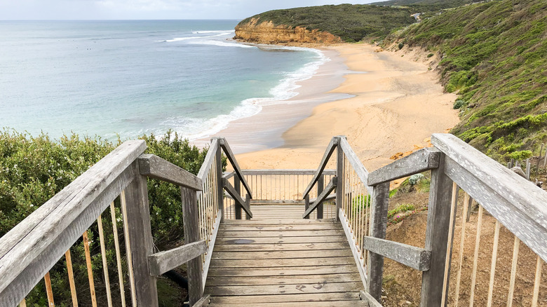
Aireys Inlet Split Point Lighthouse
One of the most gratifying aspects of the drive is the views that you will see — large rock formations stranded in the sea, caves eroded by waves, and forests where towering trees blot out the sun. But few views will compare with the one from the top of the Split Point Lighthouse. Clamber to the apex of this attraction, on a section of shore known as Shipwreck Coast, and the vistas take in the beautiful deep blue sea where dolphins or whales can be spotted, the curving coastline where broad cliffs cup sandy beaches, the shallows left on the beach by tidal movements, and the interior forests that make this part of the country so lush.
The red-domed lighthouse is open year-round and still operates at night to guide ships away from danger. After hitting the heights here, get down low on Fairhaven Beach, which is nearby. Clocking in at six kilometers (almost four miles), it's the longest stretch of beach on the Great Ocean Road.
Waterfalls
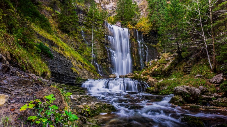
The majestic water here isn't just along the coastline. Pretty curtains of water appear in the forests set back from the sea, though they are at the most lavish after a period of rain. Near the town of Lorne, a series of waterfalls are appealing detours from the road, and you can visit one or all of them depending on how much time you have and your level of cascade commitment. The trail to Lower and Upper Kalimna Falls takes about three hours, though it's a relatively easy walk along a well-worn, if at times muddy, track. The Lower Kalimna Falls sees the torrent dropping over a lip, providing visitors enough space to get behind it. The Upper Kalimna Falls are more dramatic, a higher waterfall over a rocky chute.
Less effort is required to get to Erskine Falls, a cascade that drops about 100 feet and is close to a parking area. There are two vantage points here, one higher and one that requires a descent down 230 steps, but that lets you appreciate the true scope of the falls. Sheoak Falls is another popular stop here, also close to a car park, and, as with all the falls here, you'll pass through pretty forests to get to it. Before visiting the falls, be sure to stop by Teddy's Lookout, right on the Great Ocean Road, for some breathtaking views of the Bass Strait and Saint George River.
Kennet River
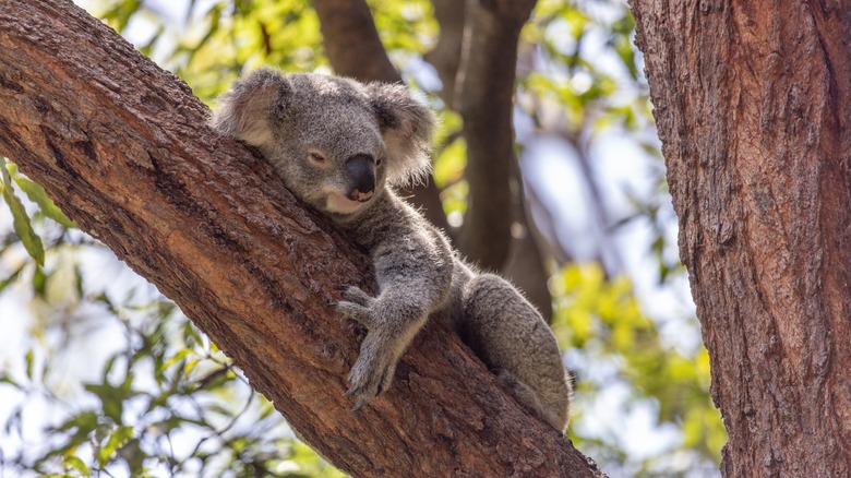
Past Lorne, the road heads southwest, where you can stop by the Kennet River for a couple of easy ambles. The Kennet River Nature Walk is a pleasant hike through a well-traveled part of the rainforest in Great Otway National Park. While the green surroundings are the main lure, the walk also presents adventurers the opportunity to do some birding, with ducks, waterfowl, and cockatoos among the avian wildlife that inhabit this part of Victoria (the state where the Great Ocean Road is located).
Another walk not far from there, the Kennet River Koala Walk starts near Koala Kafe, and promises travelers a nice easy stroll along Grey River Road. As the name of this trail suggests, the prime interest here is the chance to see koalas, solitary marsupials that only live in Australia. They reside high in eucalyptus trees and while you wander this trail, look up for the furry bundles, they're usually relaxing on a tree limb, probably half asleep!
Redwoods
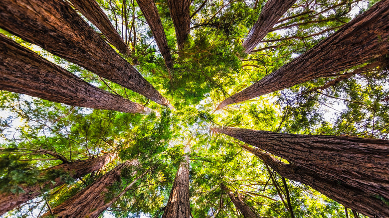
Nature lovers in the United States will be familiar with the otherworldly proportions of redwoods, the largest trees on the planet, with stunning forests in California and Oregon filled with them. In Victoria state, inland from Apollo Bay, at the Beech Forest in Great Otway National Park, you can see some of these gigantic wood skyscrapers. The Californian redwoods were planted here in the 1930s, more as an experiment into their suitability for the location than for any lasting hope for their survival. But thrive they did, and now, even at their relatively young age (redwoods can live up to 2,000 years), they are a force in the forest, a quiet, brooding presence that dominate the realm, a contrast to the open ocean road that you've been touring.
Close to this natural wonder are a couple of gorgeous waterfalls. Hopetoun Falls is a short walk from a car park, a 100-feet cascade that can be admired from the top or bottom viewing areas. Beauchamp Falls looks like it's been plucked from Rivendell in the "Lord of the Rings," a current of water that dissects the forest's magical ferns. Back in Apollo Bay, stop at Mariner's Lookout, an elevated, inland viewpoint with vistas of the ocean, rolling countryside, and town center.
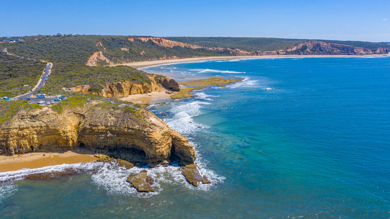
Princetown Beach
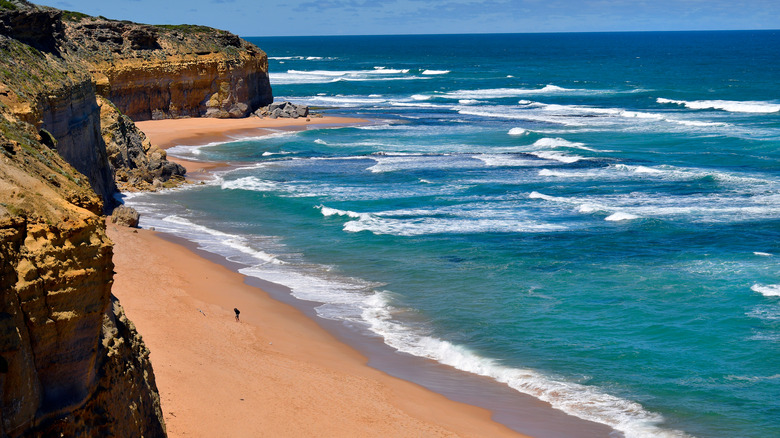
Blustery coastal beauty is what you'll find at Princetown Beach, where you can get down to the water to marvel at the sea, headlands, and dunes. This is the realm of undulating sand, pretty little bays, and rocky points that are slowly degenerating into the ocean. The Gellibrand River winds its way into the sea here through a headland called Point Ronald, creating a lagoon-type seascape. This is also where you can see remnants of an engineering undertaking from early last century, when a tunnel from the rock to the ocean was drilled to stop any obstacles from blocking the mouth of the river.
This is not a place for swimming, with competing currents from the river and ocean turning the conditions potentially treacherous, but a walk here is a get break from the road. You might also spot locals fishing, not usually allowed in marine parks but permitted here, looking to catch salmon, snapper, and trevally.
12 Apostles
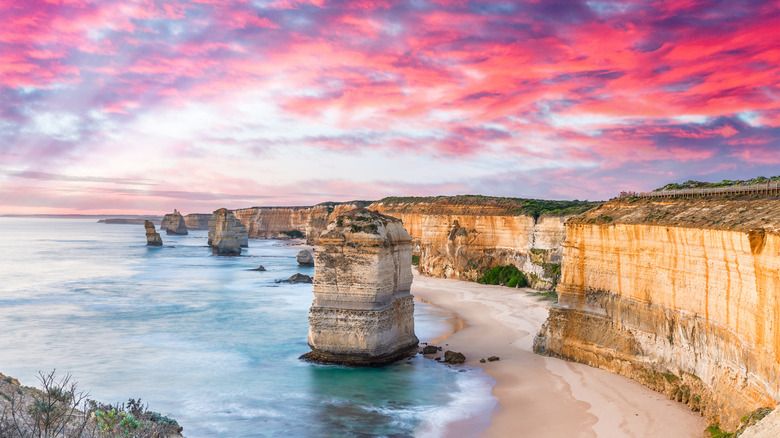
If there is one single image that represents the Great Ocean Road, it's the 12 Apostles. These rock formations in the sea are, let's be honest, the main reason that many people take this drive. One look at them, even on paper or online, and you can see why. The way they sit moored off the coast, their edges all worn and smoothed by wind and water, they almost appear like they have been dropped from the sky. Made of limestone, and some rising 150 feet above the surging water, they are an imposing spectacle, best seen from the clifftop lookout or the photo area.
Despite the name of this natural attraction, there are actually only seven stacks (there were two more, but they both collapsed), but the name has stuck. To get a better sense of the grandness of the sea sentries in this part of the country, climb down the 86-step Gibson Steps to see two of the stacks, playfully known as Gog and Magog, from sea level.
Loch Ard Gorge
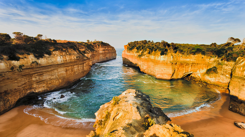
It's only a short ride from the 12 Apostles to get to this next site. You'll traverse some pretty walking tracks through bushland before getting to a gorge that looks almost prehistoric — vertiginous, smoothed cliffs that come together to enclose a small bay of gorgeous blue water. The combination of these two factors makes the destination feel very open and yet somehow eerily remote. There are numerous trails on top of the headlands that allow you to get different views of this sensational scene.
Easy to walk to from Loch Ard Gorge, Thunder Cave, is as hypnotic for its formation as for the sound here — the untamed roar of water rushing in and out of this rocky area. The cave was created by the constant erosion of an inlet by the ebb and flow of the sea, the surf crashing into the rocks. Peering into its dark recesses, you can almost imagine a fearsome marine monster residing within.
Port Campbell
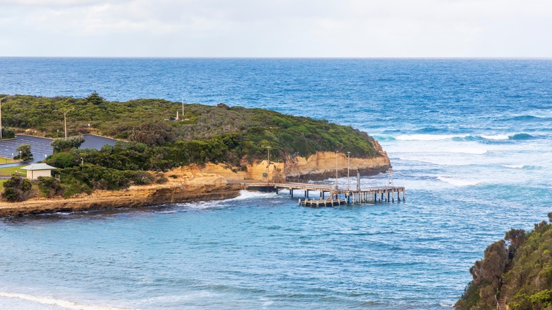
The Great Ocean Road alternates it passage between inland and along the coast, presenting a string of natural wonders to the lucky souls that traverse this route. But sometimes you need a break from the outdoor exploration, and this village offers a comforting respite from the wild wonders. Set on the back of a coastal promontory, Port Campbell is a peaceful place, perfect to explore by foot, with restaurants, cafes, small boutiques, and independent bakeries where you can stock up on sweet, flaky treats to sustain you on the road.
It's not a huge place, and the year-round population is tiny, far outnumbered by the throngs of tourists that drop by every day. But for visitors to get a feel for a small Australian coastal town, it's a great location to pass a few hours. You can come for a meal, or maybe a siesta on the small beach. To gauge the power of the sea here, head out to the Port Campbell Jetty and watch the waves crash into the limestone cliffs.
London Arch (formerly London Bridge)
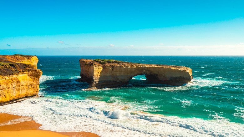
Do you know the nursery rhyme "London Bridge is Falling Down"? Its lyrics are strangely appropriate for this rock bridge, formed by the relentless actions of coastal erosion, whose connected span that extended out to sea collapsed some years ago, leaving behind an arch that sits alone in the water. Look online and you should be able to source photos that show the bridge as a more complete structure, but those photos will date to 1990 or before, which is when the bridging bit fell into the sea (apparently some tourists were stranded on the section that was cut off and had to be rescued by a helicopter).
The arch is still a sweet sight, even if you can't get on top of it anymore, visible from a couple of viewing decks. For the best range of colors to complement the hues of the rock and sea, aim to be here at sunrise or sunset.
The Grotto
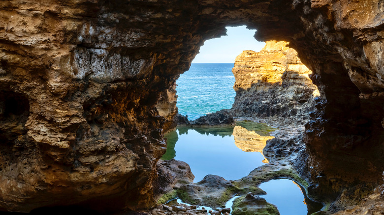
While Thunder Cave offers visitors an interesting geological formation etched by water, viewed from above, this grotto allows visitors to see the effect of erosion closer to sea level. The Grotto is a jagged, mesmerizing cave-like structure that comes replete with water views, and it is a short distance northwest of London Bridge. What makes it special is that it's not just a straightforward cave, but mixes elements of a cave, a sinkhole, and an archway, assaulted and shaped by the constant pummeling of the ocean's surf.
You can learn about the Grotto from panels that dot the headlands above it, but for a more exciting look at it, descend the steps to see it face-to-face — be careful, as the rocks are slippery from the water and sea moss. Try to time your visit for low tide, that way when you reach the Grotto, you'll be able to see through the archway and out to the sea, with the still reflections and clashing colors lending the scene an ethereal beauty.
Bay of Martyrs
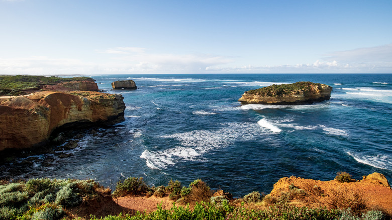
Scour all the tourism marketing material out there, and you might think that the 12 Apostles are the only set of stacks along this drive, but while they clearly receive top billing, they aren't the only show in town. At the Bay of Martyrs, located near the town of Peterborough, more limestone stacks stand sentry in the ocean. They can be comfortably seen from a viewing platform that looks west, making them a fine subject for a portrait at sunset. You could also take the steps down to the beach for a closer look.
The name of this bay, some believe, refers to a savage event at nearby Massacre Bay, where Aborigines were forced off the edge of a cliff to their death. A little northwest up the coast, Bay of Islands has viewing areas of another set of beautiful limestone stacks sitting in the ocean, their white faces contrasting with the deep blues of the roiling ocean waters.
Childers Cove
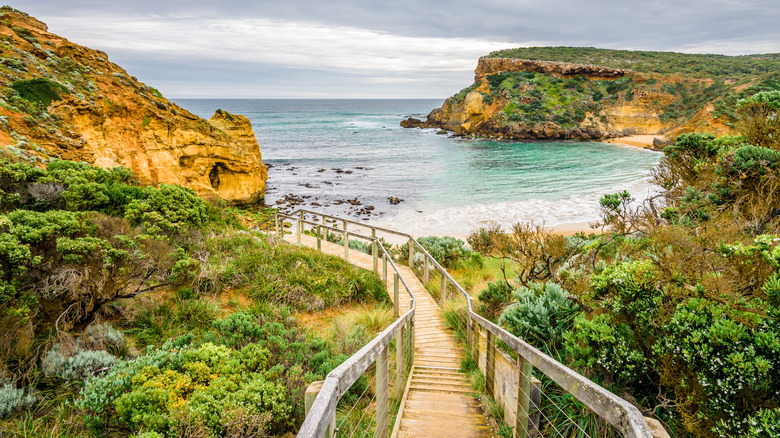
Your time on the Great Ocean Road is coming to an end, and this scenic cove near the Bay of Islands will give you a last, heartwarming reminder of the types of scenery that you've come to expect as second nature along the way. Expect to stumble upon a gorgeous horseshoe-shaped beach, with soft sand and dramatic headlands on either side that seem to only grow in stature as they reach out toward the sea.
The beach cedes to clear turquoise water that slowly transforms to dark, deep blue as the shallows drop off, and this is a fabulous spot not just to unwind, or take a refreshing dip, but also to have a picnic, or recall the fantasy of the preceding few days. It's an easy beach to get to, with steps or trails leading down from the parking area, and rocky arches at the end of it will let you frame some fabulous photos.
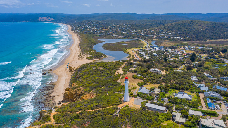
Port Fairy
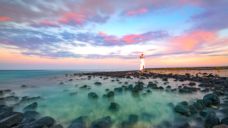
If you come here, you will have actually have just passed the end of the Great Ocean Road, but it's still a stop worth making, perhaps for an overnight stay before the drive back to Melbourne or north to the mountains of the Grampians. This seaside town is charming, as its cheerful name suggests, with wide streets, elegant cottages from the 19th century, and aged stone churches that laze under the shade of towering Norfolk pine trees. But it's not just a sleepy hamlet that's faded after a storied past. There's an active fishing industry here, evident from the local port where fishermen empty their nets of abalone and crayfish.
Port Fairy is also home to a vibrant arts scene, and the annual folk festival stages live music, activities, and plenty of good cheer. And, just as you did near the start of this wondrous journey, you can visit a lighthouse (though the tower is closed) — Griffiths Island Lighthouse sits at the end of the causeway and was built in the 1850s by Scottish masons. Little did they know that their work would become a site for tourists from all corners of the globe.